Wildfire Forces Out Hundreds of Residents in Canada's Oil Sands Hub of Fort McMurray

A picture taken through a window shows smoke rising from wildfire MWF017 on the south side of the Athabasca River valley near Fort McMurray, Alberta, Canada May 10, 2024. Alberta Wildfire/Handout via REUTERS/File Photo Purchase Licensing Rights
TT

Wildfire Forces Out Hundreds of Residents in Canada's Oil Sands Hub of Fort McMurray

A picture taken through a window shows smoke rising from wildfire MWF017 on the south side of the Athabasca River valley near Fort McMurray, Alberta, Canada May 10, 2024. Alberta Wildfire/Handout via REUTERS/File Photo Purchase Licensing Rights

Hundreds of residents in four neighborhoods in the southern end of Canada’s oil sand hub of Fort McMurray, Alberta, were ordered to evacuate with a wildfire threatening the community, authorities said Tuesday.

The Rural Municipality of Wood Buffalo said residents in Beacon Hill, Abasand, Prairie Creek and Grayling Terrace needed to leave by 4 p.m.

An emergency evacuation warning remained in place for the rest of Fort McMurray and surrounding areas.

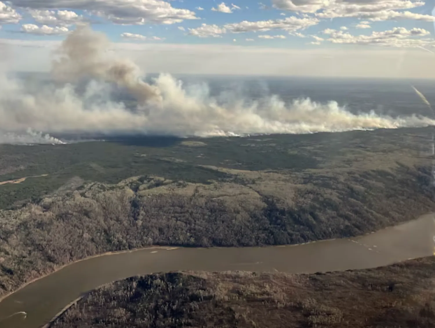
The rural municipality said the residents in the four neighborhoods were being ordered out to clear room for crews to fight the fire, which had moved to within 13 kilometers (8 miles) of the city, The AP reported.

Fort McMurray has a population of about 68,000, and a wildfire there in 2016 destroyed 2,400 homes and forced more than 80,000 people to flee.

“It’s very important for me to know that this fire activity is very different than the 2016 Horse River wildfire. We have an abundance of resources and we are well positioned to respond to this situation,” Regional Fire Chief Jody Butz said.

Suzy Gerendi, who runs the dessert shop in the Beacon Hill neighborhood, said she was already packed up when the evacuation order came down. Gerendi lived in Beacon Hill when fire overtook it in 2016.

She immediately began the drive towards Edmonton, Alberta with her three dogs.

“It’s very, very dark and orange,” Gerendi said. “It brings up some memories and it’s not a good feeling.”

Residents were also dealing with heavy smoke and ash.

“It’s dark. The smoke is everywhere,” said resident Else Hoko.

Hoko picked up her two sons from school in Abasand after receiving the evacuation order. She had also fled in 2016.

“I’m so stressed,” she said, adding that she’s praying for rain.

The Beacon Hill and Abasand neighborhoods saw serious losses in 2016.

The current fire has grown to about 110 square kilometers (42.5 square miles) and remains out of control.

Josee St. Onge, an Alberta Wildfire information officer, said wind is pushing the fire toward the community.

She said crews have been pulled from the fire line for safety reasons, and air tankers and helicopters continue to drop water and retardant on the “active edges.”

“Unfortunately, these are not favorable winds for us, and the fire will continue to advance towards the town until we see a wind shift,” she said.

More than 230 wildfires were burning across western Canada, most of them in British Columbia, where about 130 were counted, officials said.

In the northeast of the neighboring province of British Columbia, areas subject to mandatory evacuation increased, with the latest order Monday for Doig River First Nation and the Peace River Regional District as a fire threatened nearby.

Forecasts on Tuesday called for wind that could blow a growing wildfire closer to Fort Nelson. Emergency workers had been phoning as many of the estimated 50 residents still in town and urging them to go.

The British Columbia Wildfire Service said the blaze had grown to 84 square kilometers (32 miles). On Monday, it was about 53 square kilometers (21 miles) in size. A photo by the service shows the billowing blaze spreading in a vast wooded area.

The community of about 4,700 and the neighboring Fort Nelson First Nation have been under an evacuation order since Friday.

Northern Rockies Regional Municipality Mayor Rob Fraser said one drawback of the evacuation is the challenge for essential staff, including firefighters, to find food.

“This is really going to be weather dependent, and so far the weather has been holding with us,” Fraser said of the wildfire in a video posted to Facebook.

In 2023, Canada experienced a record number of wildfires that caused choking smoke in parts of the US and forced more than 235,000 Canadians to evacuate their communities. At least four firefighters died.


Climate Change Causing More Change in Rainfall, Fiercer Typhoons, Scientists Say 

People and vehicles wade through the water along a street that was flooded by Typhoon Gaemi in Kaohsiung on July 25, 2024. (AFP)
TT

Climate Change Causing More Change in Rainfall, Fiercer Typhoons, Scientists Say 

People and vehicles wade through the water along a street that was flooded by Typhoon Gaemi in Kaohsiung on July 25, 2024. (AFP)

Climate change is driving changes in rainfall patterns across the world, scientists said in a paper published on Friday, which could also be intensifying typhoons and other tropical storms.

Taiwan, the Philippines and then China were lashed by the year's most powerful typhoon this week, with schools, businesses and financial markets shut as wind speeds surged up to 227 kph (141 mph). On China's eastern coast, hundreds of thousands of people were evacuated ahead of landfall on Thursday.

Stronger tropical storms are part of a wider phenomenon of weather extremes driven by higher temperatures, scientists say.

Researchers led by Zhang Wenxia at the China Academy of Sciences studied historical meteorological data and found about 75% of the world's land area had seen a rise in "precipitation variability" or wider swings between wet and dry weather.

Warming temperatures have enhanced the ability of the atmosphere to hold moisture, which is causing wider fluctuations in rainfall, the researchers said in a paper published by the Science journal.

"(Variability) has increased in most places, including Australia, which means rainier rain periods and drier dry periods," said Steven Sherwood, a scientist at the Climate Change Research Center at the University of New South Wales, who was not involved in the study.

"This is going to increase as global warming continues, enhancing the chances of droughts and/or floods."

FEWER, BUT MORE INTENSE, STORMS

Scientists believe that climate change is also reshaping the behavior of tropical storms, including typhoons, making them less frequent but more powerful.

"I believe higher water vapor in the atmosphere is the ultimate cause of all of these tendencies toward more extreme hydrologic phenomena," Sherwood told Reuters.

Typhoon Gaemi, which first made landfall in Taiwan on Wednesday, was the strongest to hit the island in eight years.

While it is difficult to attribute individual weather events to climate change, models predict that global warming makes typhoons stronger, said Sachie Kanada, a researcher at Japan's Nagoya University.

"In general, warmer sea surface temperature is a favorable condition for tropical cyclone development," she said.

In its "blue paper" on climate change published this month, China said the number of typhoons in the Northwest Pacific and South China Sea had declined significantly since the 1990s, but they were getting stronger.

Taiwan also said in its climate change report published in May that climate change was likely to reduce the overall number of typhoons in the region while making each one more intense.

The decrease in the number of typhoons is due to the uneven pattern of ocean warming, with temperatures rising faster in the western Pacific than the east, said Feng Xiangbo, a tropical cyclone research scientist at the University of Reading.

Water vapor capacity in the lower atmosphere is expected to rise by 7% for each 1 degree Celsius increase in temperatures, with tropical cyclone rainfall in the United States surging by as much as 40% for each single degree rise, he said.