'Lungs of the Earth': the Indonesians Fighting for Peatland

Indonesia has more tropical peatland than any country, but it is also quickly losing this poorly understood ecosystem. STR / AFP
TT

'Lungs of the Earth': the Indonesians Fighting for Peatland

Indonesia has more tropical peatland than any country, but it is also quickly losing this poorly understood ecosystem. STR / AFP

Indonesian environmentalist Pralensa steered his boat through a shallow canal in the marshy peatlands near his village, an environment he fears may soon disappear.

His oar stirred up rich organic material in the brackish water, evidence of the layers of plant matter that make peatlands vital carbon dioxide stores and key to biodiversity, AFP said.

Indonesia has more tropical peatland than any other country, but it is also quickly losing this poorly understood ecosystem.

That affects local residents and wildlife but also has global impacts, because converted peatland can release vast quantities of planet-warming carbon dioxide.

Pralensa worries a similar fate awaits much of the swampy peatland around his village of Lebung Itam in South Sumatra.

Locals say palm oil firm Bintang Harapan Palma has already begun digging canals to drain the peatlands for planting.

"We protested... we told them this is a community-managed area," said Pralensa, who, like many Indonesians, uses a single name.

"According to them, they already have rights to this land."

Bintang Harapan Palma did not respond to AFP's request for comment.

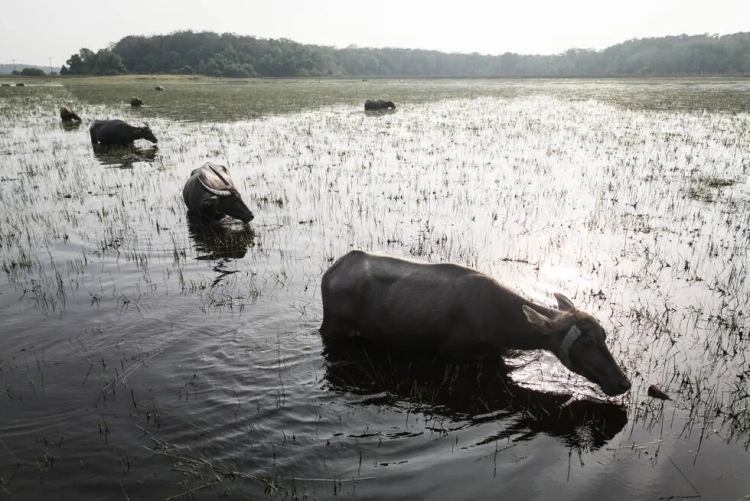
Peatlands are an in-between place -- seemingly neither water nor land -- an environment that slows plant decomposition and forms carbon-rich peat.

Covering just three percent of the world's surface, they hold an estimated 44 percent of all soil carbon.

Indonesia's peatlands are home to endangered orangutans, as well as economically important fish species. They also help prevent flooding and drought, lower local temperatures and minimize saltwater intrusion.

For Pralensa, peatlands are no less than a "spiritual bond".

"From the moment that we exist, that we're born, we are aware of this peatland. We encounter it every moment of every day," the 44-year-old said.

Catastrophic fires

Indonesia's peatland has long been converted for agriculture, drained of the water that is its lifeblood, with severe consequences.

Dry peat is highly flammable, and fire can smoulder underground and reignite seemingly at will.

The blazes sparked calls for action, including a moratorium on new peatland concessions.

Government regulations adopted the following year banned several damaging activities, including burning and drying out peatland.

The environment ministry did not respond to questions submitted by AFP.

"Weak oversight and law enforcement in Indonesia allow the exploitation of peatlands to continue," said Wahyu Perdana at peatland preservation NGO Pantau Gambut.

And fires still happen "almost every year," said Rohman, a farmer in Bangsal village, around two hours west of Lebung Itam.

Like Lebung Itam, it is ringed by plantations on converted peatland.

Bangsal residents could once rely on vast wetlands to feed their distinctive buffalo, which dive beneath the water to graze.

Fish traps supplied additional income, along with small rice paddies.

'We must protect nature'

Plantation infrastructure prevents water from subsiding properly when the rains end, complicating rice planting.

And then there is the seasonal haze.

"It's difficult to do anything" when it descends, said Rohman, with visibility sometimes dropping to just a few meters.

Everything from "economic activity to children playing and learning is very disrupted".

Rohman, 53, was one of several plaintiffs from Bangsal and Lebung Itam who filed a landmark lawsuit over the fires.

They argued three companies with nearby timber plantations on peatland bore legal responsibility for the health, economic and social impacts of local fires.

Filing the suit was not an easy decision, said Bangsal schoolteacher Marda Ellius, who alleges a company named in the case offered her money and help for her family if she withdrew.

"I kept thinking that, from the beginning, my goal here was for the environment, for many people," she said.

"I chose to continue."

AFP could not reach the companies named in the suit. Major firm Asia Pulp & Paper (APP), which buys from the three companies, did not respond.

This month, a local court rejected the suit, saying the plaintiffs lacked standing.

"The pain cannot be described," plaintiff Muhammad Awal Gunadi said of the ruling.

"It was tough because we were facing corporations.

The group has pledged to appeal, and Bangsal's villagers are lobbying local government for a new designation to protect their remaining peatland.

Healthy peat is "like the lungs of the Earth," said Bangsal resident and buffalo farmer Muhammad Husin.

"Hopefully, if we protect nature, nature will also protect us."


Saudi Arabia Reaffirms Commitment to Environmental Action on Saudi Green Initiative Day

One of the mountainous areas located in the south of the Kingdom of Saudi Arabia (Asharq Al-Awsat)
TT

Saudi Arabia Reaffirms Commitment to Environmental Action on Saudi Green Initiative Day

One of the mountainous areas located in the south of the Kingdom of Saudi Arabia (Asharq Al-Awsat)

The Saudi Green Initiative (SGI) Day, observed annually on March 27 following a Cabinet decision, reflects the Kingdom's commitment to establishing a culture of sustainability, enhancing national environmental efforts, and encouraging all sectors to achieve sustainable development goals in line with Vision 2030, SPA reported.

The initiative recently achieved a significant national milestone by rehabilitating one million hectares of degraded land through the National Greening Program, overseen by the National Center for Vegetation Cover Development and Combating Desertification. This objective aims to expand vegetation cover, reduce desertification, improve quality of life, and enhance the natural capacity of local environments to adapt to climate change.

The achievement is an extension of the Kingdom's broader efforts to protect natural resources, reduce emissions, promote reliance on clean energy, and preserve biodiversity, thereby strengthening Saudi Arabia's regional and international standing in environmental action.

Over the past year, the initiative has continued to make tangible progress. More than 159 million trees were planted across the Kingdom, and environmental reserves saw the birth of Arabian oryx calves for the third consecutive year. Furthermore, the National Water Efficiency and Conservation Center currently saves 120,000 cubic meters of water daily, with plans to increase this capacity to 300,000 cubic meters.

These combined efforts align with the objectives of Vision 2030 and contribute to strengthening the Kingdom’s regional and international standing in environmental sustainability.

SGI Day is observed annually to highlight the initiative’s achievements, review its future goals, and encourage broad sector participation in environmental efforts and sustainable development.

These efforts reflect the Kingdom’s approach to environmental and climate action, driven by the Saudi Green Initiative and the Middle East Green Initiative, both launched by Prince Mohammed bin Salman bin Abdulaziz Al Saud, Crown Prince and Prime Minister, underscoring its ongoing commitment to supporting the transition toward a more sustainable development model.


Satellite Observations Offer Insight into a Tsunami’s Early Stages

A person shows a cell phone displaying a message to evacuate to a tsunami safety zone during an evacuation of the coast following a tsunami warning issued by local authorities after an earthquake struck the Kamchatka Peninsula in the far east of Russia, triggering warnings and evacuations across the South Pacific, in Dichato, near Concepcion, Chile, July 30, 2025. (Reuters)
TT

Satellite Observations Offer Insight into a Tsunami’s Early Stages

A person shows a cell phone displaying a message to evacuate to a tsunami safety zone during an evacuation of the coast following a tsunami warning issued by local authorities after an earthquake struck the Kamchatka Peninsula in the far east of Russia, triggering warnings and evacuations across the South Pacific, in Dichato, near Concepcion, Chile, July 30, 2025. (Reuters)

Observations made by a satellite operated by the US and French space agencies shortly after a strong earthquake struck off Russia's Kamchatka Peninsula last year are giving scientists a better understanding of how tsunamis originate and propagate.

The researchers said the findings may help improve understanding of future tsunamis and earthquakes at subduction zones, particularly near the ocean trench where two tectonic plates meet and one slides beneath the other. The strongest tsunamis often are generated by such quakes.

The magnitude 8.8 quake struck on July 29, 2025, triggering a tsunami that spread across the Pacific Ocean. A tsunami - a series of extremely long and powerful ocean waves - is caused by large movements of the seafloor that push water up or down, often during earthquakes or landslides that occur under water.

The NASA-CNES Surface Water and Ocean Topography, or SWOT, satellite ‌made its observations ‌within 70 minutes of the start of the earthquake. It observed not ‌only ⁠the leading wave ⁠of the tsunami, but also a distinct pattern of smaller waves trailing behind it.

Such wave patterns had long been predicted in computer models and theoretical studies, but had been difficult to confirm with real-world observations, the researchers said.

"I believe SWOT represents a new lens for observing and studying tsunamis and their generation," said Ignacio Sepúlveda, a professor of coastal engineering at San Diego State University and lead author of the study published this week in the journal Science.

"It is also likely to improve our understanding of the physical mechanisms that generate tsunamis, including earthquakes," ⁠Sepúlveda added.

Traditional deep-ocean pressure sensors and other satellites have limitations in coverage ‌and measurement, making it difficult to capture the full structure of ‌the waves, especially near the trench, the researchers said.

SWOT scans a wide swath of the ocean, producing two-dimensional maps ‌of sea surface height. This allows scientists to see the shape, direction and spacing of tsunami waves ‌in much greater detail.

Tsunamis are among the strongest and most destructive natural forces, with powerful waves radiating from a point of origin outward in all directions. These waves can cause damaging and deadly coastal flooding.

The tsunami in this study did not cause significant loss of life, but others have caused huge death tolls such as the 2004 Indian Ocean ‌tsunami that killed some 230,000 people.

The July 2025 tsunami originated within about 10 kilometers (six miles) of the trench, the place in the seafloor ⁠where two tectonic plates intersect, ⁠the researchers found. This location could not previously be determined using traditional land-based instruments or sparse sensors on the seafloor alone.

Earth's surface is made up of immense plates that move very gradually in a geological process called plate tectonics.

The researchers found that when earthquake-caused movement extends close to the trench, it can generate shorter waves that travel more slowly and spread out over time, forming a trailing pattern behind the main tsunami front. This behavior means that different parts of the wave move at different speeds, with longer waves moving more quickly and leading, while shorter ones lag behind.

The study also showed that the strength of the trailing waves increases when earthquake movement extends closer to the trench, suggesting these waves are linked to where and how the tsunami was generated near the trench.

"This opens a new window to understand in a better way what happens with earthquakes and tsunamis near the trench," Sepúlveda said, referring to SWOT observations. "In the future, this knowledge will allow us to improve models we use to evaluate tsunami hazards in coastal communities and make them more resilient."


Gabon Battles for Baby Sea Turtles’ Survival

 An olive ridley sea turtle hatchling moves on a beach after emerging from its nest near Libreville on February 15, 2026. (AFP)
An olive ridley sea turtle hatchling moves on a beach after emerging from its nest near Libreville on February 15, 2026. (AFP)
TT

Gabon Battles for Baby Sea Turtles’ Survival

 An olive ridley sea turtle hatchling moves on a beach after emerging from its nest near Libreville on February 15, 2026. (AFP)
An olive ridley sea turtle hatchling moves on a beach after emerging from its nest near Libreville on February 15, 2026. (AFP)

Small enough to fit in the palm of your hand, newly hatched sea turtles emerged on a Gabonese beach to embark on the treacherous 10-meter (33-foot) scramble across the sand to the ocean.

"The survival rate for turtles is one in 1,000," Francois Boussamba, a Gabonese turtle expert and head of the NGO Aventures Sans Frontieres (Adventures Without Borders), told AFP, scouring for nests.

Conservationists from NGOs and the national parks agency patrol Gabon's beaches daily during the nesting season to protect the turtles' nests.

Those under threat are moved to a hatchery, a fenced enclosure near the sea, where the eggs are kept safe until they are ready to hatch.

On Pongara National Park's white sandy beaches, about 30 minutes by boat from the capital Libreville, conditions are optimal for nesting: wild coastline, a favorable equatorial climate and an open ocean beach with gentle slopes, ideal for the females.

But dangers lurk. Nests are threatened by coastal erosion due to encroaching sea levels, or myriad predators such as crabs and birds that prevent the eggs from reaching their 60-day incubation period, Boussamba said.

"The chances of survival are tiny," he said.

- Muscle up -

In Libreville, every morning around 7:00 am, volunteers from the Project Turtles Tahiti Gabon association crisscross the beach and check the nests in the hatchery.

After one has hatched, the baby turtles have to be moved so they can reach the sea -- but they are never put straight into the water.

"They need to build up their muscles so they can swim in the ocean," volunteer Clemence said.

Four species of turtles -- green, olive ridley, hawksbill and leatherback -- come to nest along Gabon's 900 kilometers (560 miles) of coastline from October to April.

It has the highest nesting density on the African continent, according to the US-based NGO Wildlife Conservation Society.

Gabon is the world's leading nesting site for the leatherback turtle, the largest of the species and listed as threatened by the International Union for Conservation of Nature (IUCN).

In addition to predators, sea turtles are also threatened by human activities, from plastic pollution to industrial fishing and poachers.

By watching over the eggs, the rangers in Pongara help ensure "the survival of this species", Edouard Moussavou, Pongara park's deputy director, said.

- Unpaid wages -

Since 2013, Gabon's conservation efforts had received funding from the United States, notably through the US Fish and Wildlife Service, an agency responsible for biodiversity.

"If there are turtles, it means our ecosystem is sound and healthy," Boussamba said.

But since the suspension of grants by the administration of US President Donald Trump, "turtle monitoring activities have stopped or slowed down drastically", Moussavou said.

"There will be fewer staff, less data, and that really creates difficulties for us," he said.

Additionally, there have been delays in paying the staff of the National Agency for National Parks (ANPN), which manages the country's 13 parks, according to Sosthene Ndong Engonga, secretary-general of the National Union of Gabonese Ecoguards.

The around 580 eco-rangers regularly go unpaid.

"Even when there is money, we have to make a big fuss to get our salaries," he said, adding he battled with the treasury last month for back pay.

The eco-rangers, who are crucial for the conservation of Gabon's biodiversity, face having "to give everything up," Engonga warned. "We have expenses we can no longer cover," he said.

On Pongara beach, 40-year-old Alain Banguiya carries out night patrols, hoping to see a leatherback turtle emerge from the water to lay her eggs in the sand.

An eco-ranger since 2015, he has not been paid for two months but says that giving up is out of the question.

"We have a duty to fight to the end, to keep our spirits up," he said. "Despite the obstacles, we stay the course: conservation."