What Is Japan’s Nankai Trough Megaquake Advisory?

 Japan's earthquake experts panel chief Naoshi Hirata talks about probability of megaquake on the Nankai Trough; in Tokyo, Japan, 08 August 2024 (issued 09 August 2024) after a magnitude 7.1 earthquake hit southwestern Japan on the day. (EPA/JIJI Press)
Japan's earthquake experts panel chief Naoshi Hirata talks about probability of megaquake on the Nankai Trough; in Tokyo, Japan, 08 August 2024 (issued 09 August 2024) after a magnitude 7.1 earthquake hit southwestern Japan on the day. (EPA/JIJI Press)
TT

What Is Japan’s Nankai Trough Megaquake Advisory?

 Japan's earthquake experts panel chief Naoshi Hirata talks about probability of megaquake on the Nankai Trough; in Tokyo, Japan, 08 August 2024 (issued 09 August 2024) after a magnitude 7.1 earthquake hit southwestern Japan on the day. (EPA/JIJI Press)
Japan's earthquake experts panel chief Naoshi Hirata talks about probability of megaquake on the Nankai Trough; in Tokyo, Japan, 08 August 2024 (issued 09 August 2024) after a magnitude 7.1 earthquake hit southwestern Japan on the day. (EPA/JIJI Press)

Japan issued its first-ever advisory on higher-than-usual risks of a megaquake, after a strong magnitude 7.1 quake occurred on Thursday at the edge of a tremulous seabed zone along the Pacific coast known as the Nankai Trough.

A possible Nankai Trough megaquake and tsunami disaster could kill hundreds of thousands of people and cause a trillion-dollar damage to Japan.

Here's a look at the risks of what could be the biggest natural disaster in Japan's modern history.

WHAT IS THE NEW RISK OF A MEGAQUAKE?

Japan's Nankai Trough quake advisory panel said the chance of a bigger earthquake striking after a magnitude 7 tremor was once in a few hundred cases, relatively higher than regular times. Earthquakes with a magnitude larger than 8 are considered megaquakes.

Japan estimates the next Nankai Trough megaquake could be as powerful as magnitude 9.1.

University of Tokyo professor Naoshi Hirata, who chairs the panel, said in a press conference that residents in areas that would be hit by such a disaster should review evacuation procedures and stay vigilant for a week.

Japan is one of the world's most earthquake-prone nations sitting on the Pacific "Ring of Fire" arc of volcanoes and oceanic trenches. In 2011, more than 15,000 people were killed in a magnitude 9.0 quake in northeast Japan that triggered a tsunami and triple reactor meltdowns at a nuclear power plant.

WHAT IS NANKAI TROUGH AND WHY IS IT SIGNIFICANT FOR QUAKES?

The Nankai Trough is off its southwest Pacific coast and runs for approximately 900 km (600 miles), where the Philippine Sea Plate is subducting under the Eurasian Plate and the accumulating tectonic strains could result in a megaquake roughly once in 100 to 150 years.

The Japanese government had previously predicted a 70-80% chance of a magnitude 8 to 9 earthquake happening along the Trough in the next 30 years.

The magnitude of an earthquake is related to the length of the fault on which it occurs, according to the United States Geological Survey. The largest earthquake ever recorded was a magnitude 9.5 on May 22, 1960 in Chile on a fault that is almost 1,000 miles long.

THE POTENTIAL DAMAGE FROM NANKAI TROUGH QUAKE AND TSUNAMI

A megaquake could result in maximum measurable tremors to areas from central Shizuoka - about 150 km (93 miles) south of capital Tokyo - to southwestern Miyazaki.

Tsunami of up to 30 meters (98 feet) may reach Japan's Pacific coasts within minutes after the quake, depending on the epicenter and tidal situation.

Coupled with landslides and fire, the disaster would be expected to claim the lives of as many as 323,000 people and destroy 2.38 million buildings, forcing nearly 10 million survivors to evacuate.

Economic damage could total up to 220 trillion yen ($1.50 trillion), or more than a third of Japan's annual gross domestic product, with long-lasting impacts on infrastructure and supply chains for coastal industrial powerhouses producing cars and other key Japanese products.

PREVIOUS NANKAI TROUGH RELATED QUAKES

Nankai Trough earthquakes have been marked on Japan's historic records multiple times since 684, often with accounts of tsunamis striking coastal villages.

The most recent Nankai Trough quake happened in 1946 with magnitude 8.0 tremor and 6.9 meter tsunami, killing 1,330 people.

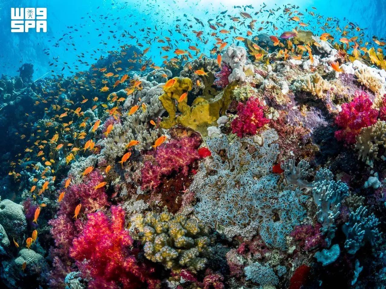
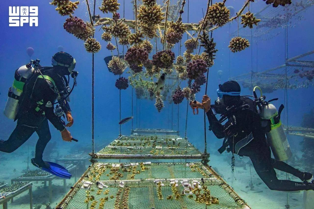
KAUST Unveils Landmark Coral Facility on Red Sea, Advancing Saudi Scientific Expertise and Marine Conservation

KCRI is designed to restore the Red Sea reefscape and offer a framework that coral restoration programs worldwide can adopt. (SPA)
TT

KAUST Unveils Landmark Coral Facility on Red Sea, Advancing Saudi Scientific Expertise and Marine Conservation

KCRI is designed to restore the Red Sea reefscape and offer a framework that coral restoration programs worldwide can adopt. (SPA)

The King Abdullah University of Science and Technology (KAUST) launched the KAUST Coral Restoration Initiative’s large-scale coral facility, restoring and advancing one of Saudi Arabia’s most precious natural assets, reported the Saudi Press Agency on Wednesday.

On Saudi Arabia’s Red Sea coast, the KAUST Coral Restoration Initiative (KCRI) land-based nursery and research campus is now growing corals at scale. It is designed to produce up to 360,000 corals a year, to outplant more than two million corals across 100 hectares of reef at Shushah Island by 2030, and to establish a resilient reef ecosystem by 2040.

This opening of the world’s largest coral restoration facility, announced at COP31 in Antalya, arrives at a moment of acute urgency for the world’s reefs. The fourth global coral bleaching event, confirmed by NOAA as the most severe in recorded history, affected more than 84% of the world’s reef area between 2023 and 2025.

Coral reefs support around a quarter of all marine species, protect coastlines from storms and sustain the livelihoods of more than 500 million people. (SPA)

The Red Sea is the right place to start. Its corals live in some of the warmest, saltiest waters on Earth, and they hold lessons about resilience that reefs everywhere will need. KCRI combines the Red Sea’s unique corals with KAUST’s world-class marine science to learn how corals can be grown at scale and conditioned to withstand warmer water before they return to the reef.

The initiative also draws on the expertise of the Coral Research and Development Accelerator Platform (CORDAP), which works internationally to accelerate scientific and technological solutions for coral reef conservation and restoration.

KCRI brings four components together in a single restoration system, including a large-scale land-based coral nursery, sea-based nurseries, more than 50 research programs spanning coral probiotics, heat-resilient corals, robotics and AI-driven modelling and eCoral, an AI-driven digital twin of the reefscape that guides where and how every coral is planted and monitored.

Saudi scientists, divers and aquarists are playing an important role in KCRI’s restoration efforts, developing specialist expertise in coral cultivation, marine science and reef restoration. (SPA)

Saudi scientists, divers and aquarists are playing an important role in KCRI’s restoration efforts, developing specialist expertise in coral cultivation, marine science and reef restoration. Beyond its restoration activities, KCRI represents a long-term investment in Saudi Arabia’s marine science capabilities.

Coral reefs support around a quarter of all marine species, protect coastlines from storms and sustain the livelihoods of more than 500 million people. KCRI is designed to restore the Red Sea reefscape and offer a framework that coral restoration programs worldwide can adopt.

KAUST is also working with international partners on how coral diversity can be safeguarded for future generations.


Portugal Closes All Schools and Non-Essential Services Ahead of a Major Atlantic Storm

Heavy machinery clears the debris from a landslide along the Marocos road in Machico municipality, on the Portuguese island of Madeira, due to severe weather caused by the passage of Storm Charles, 11 November 2026. (EPA)
TT

Portugal Closes All Schools and Non-Essential Services Ahead of a Major Atlantic Storm

Heavy machinery clears the debris from a landslide along the Marocos road in Machico municipality, on the Portuguese island of Madeira, due to severe weather caused by the passage of Storm Charles, 11 November 2026. (EPA)

Portugal closed all schools and shuttered non-essential public services on Wednesday as a major Atlantic storm headed for the country's mainland.

Streets remained largely deserted ahead of the arrival of Storm Charles after the government told people to stay at home as heavy rain and rough seas were expected to batter the Portuguese coast, with wind gusts of up to 140 kph (85 mph).

It was the first time in living memory that Portugal’s roughly 8,000 schools had canceled classes nationwide over a storm forecast.

Buses without passengers drove through the country's capital, Lisbon, where some streets flooded due to clogged drains. A national supermarket chain closed its stores, while an international technology conference in Lisbon attended by around 70,000 people called off the day's events.

In January, the country's center-right government faced harsh criticism for its weak response when Storm Kristin hit central Portugal, felling thousands of trees and causing widespread property damage that is still being repaired.

The brunt of Storm Charles was expected to hit the Atlantic coast on Wednesday afternoon and evening, coming from the southwest after it had struck the Portuguese island of Madeira on Tuesday with 130 kph (81 mph) winds.


Once the World's Fastest, Ocean Liner Will Become Largest Artificial Reef

The S.S. United States crossed the Atlantic more than 800 times. (Getty Images)
TT

Once the World's Fastest, Ocean Liner Will Become Largest Artificial Reef

The S.S. United States crossed the Atlantic more than 800 times. (Getty Images)

An ocean liner that is longer than the Titanic and was once the fastest on the seas is headed to a final home on the floor of the Gulf of Mexico as the world's largest artificial reef.

The S.S. United States is scheduled to be sunk Wednesday off the coast of the Florida Panhandle, fulfilling a long-planned $13.5 million project aimed at attracting more divers and fishing enthusiasts to the area while creating a home for tuna, marlin and swordfish.

The project will keep what had been a technological marvel when it made its maiden voyage in 1952 from becoming scrap metal.

The S.S. United States crossed the Atlantic more than 800 times, carrying old Hollywood stars like Grace Kelly and Elizabeth Taylor. Other passengers have included President John F. Kennedy and Britain’s former King Edward VIII. In 1968, a young Bill Clinton took it when he went to Oxford University, decades before he was elected president.

In preparation for the sinking, organizers removed the 65-foot smokestacks and plan to have them anchor a new museum that celebrates the ship. Once aboard, passengers were treated to dinners that included caviar, roast duckling, smoked ox tongue and Calf's Head en Tortue.

“It was our goal to make sure that she wasn’t lost forever,” said David Lawrence, a member of the board for the S.S. United States Conservancy, which is dedicated to preserving the ship.

The ship will be sunk without using explosives

Federal environmental and explosives rules prevent Okaloosa County, Florida, and its contractor from using explosives to scuttle the ship, said Nick Tomecek, the county's spokesperson. Concerns about inclement weather prompted officials to move up the sinking by a day.

The S.S. United States has pipes that pulled seawater into tanks as part of the system that cooled its boilers, he said, and those tanks have been removed so that once the valves are opened, water will flood the hull. Workers also have cut 10-foot by 10-foot holes in the decks, and more than 400 portholes have been removed.

The ship is to sink in about 180 feet (55 meters) of water, with its top deck about 60 feet (18 meters) below the surface — shallow enough that inexperienced divers can visit. It will settle on the floor of the waters about 25 miles (40 kilometers) southwest of Destin, between Panama City and Pensacola.

Larger than the Titanic, the ship's first voyage set a speed record

More than 3,000 workers helped build the S.S. United States in 1950 and 1951 in Virginia. An Associated Press reporter and President Harry Truman's daughter, Margaret, were among 1,700 passengers for the first voyage.

The ship's average speed for that trip was almost 41 miles (66 kilometers) per hour, besting a record set by Britain's R.M.S. Queen Mary in 1938 by 4.5 miles (7.2 kilometers) per hour, according to the AP's dispatch.

The S.S. United States set the record even though its journey ended in the face of a full gale that reached 69 miles (111 kilometers) per hour — “so strong it blew a ping pong table off the deck,” AP reported.

At 990 feet (302 meters), the ship is 108 feet (33 meters) longer than the ill-fated Titanic, which hit an iceberg and sank on its first voyage across the Atlantic.

“She really embodies and expresses this country’s best,” said Susan Gibbs, the granddaughter of the ship's designer. “She represents pride and resilience and strength and beauty.”

The ship's resting place has many artificial reefs

About 500 artificial reefs are located in the waters near where the S.S. United States will rest, Tomecek said.

Previously, the largest artificial reef came from the 2006 scuttling of an aircraft carrier, the USS Oriskany in the Gulf off of Pensacola — near enough to the S.S. United States site that an experienced diver could visit both in the same day, Tomecek said. The Oriskany, launched in 1950, was 911 feet (278 meters) in length.

“We're trying to be the best diving destination in the world,” Tomecek said.

The ship was decommissioned in 1969. Attempts by a hotel magnate and Norwegian Cruise Lines to use the ship never floated, and from 1996 until recently, it sat along a dock in Philadelphia.

“I’m just so happy that we are able to save parts of her,” Gibbs said.