Highways in Cairo's Historic City of the Dead

A tomb from the early 20th Century stands partially demolished amid construction of a new highway through the Northern Cemetery in Cairo, Egypt, Sunday, July 26, 2020. Dozens of graves have been partially or fully destroyed as the government builds two large expressways through the City of the Dead, a UNESCO World Heritage Site. (AP Photo/Nariman El-Mofty)
TT

Highways in Cairo's Historic City of the Dead

A tomb from the early 20th Century stands partially demolished amid construction of a new highway through the Northern Cemetery in Cairo, Egypt, Sunday, July 26, 2020. Dozens of graves have been partially or fully destroyed as the government builds two large expressways through the City of the Dead, a UNESCO World Heritage Site. (AP Photo/Nariman El-Mofty)

For centuries, sultans and princes, saints and scholars, elites and commoners have been buried in two sprawling cemeteries in Egypt´s capital, creating a unique historic city of the dead. Now in its campaign to reshape Cairo, the government is driving highways through the cemeteries, raising alarm from preservationists.

In the Northern Cemetery last week, bulldozers demolished walls of graves, widening a road for a new expressway. The graves are from the early 20th Century, including elaborate mausoleums of well-known writers and politicians. The ornate, 500-year-old domed tomb of sultan towers in the construction´s path and, though untouched, will likely be surrounded on either side by the multi-lane highway.

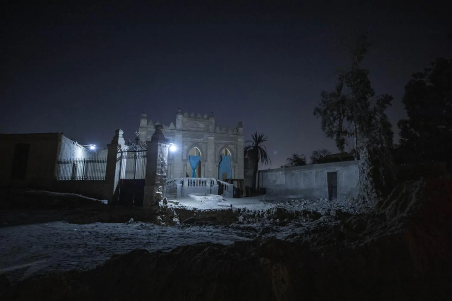
In the older Southern Cemetery, several hundred graves have been wiped away and a giant flyover bridge swiftly built. In its shadow sits the mosque-shrine of one of Egypt´s earliest prominent Islamic clerics, Imam Leith, from the 700s.

As bulldozers worked, families rushed to move the bodies of their loved ones. Others faced losing their homes: though known as the City of the Dead, the cemeteries are also vibrant communities, with people living in the walled yards that surround each gravesite.

Cairo´s governorate and the Supreme Council of Antiquities underlined that no registered monuments were harmed in the construction.

"It is impossible that we would allow antiquities to be demolished," the head of the council, Mostafa al-Waziri, said on Egyptian TV. He said the affected graves are from the 1920s and 1940s, belonging to individuals who will be compensated.

The government has carried out a furious campaign of bridge and highway building in Cairo and around the country. Authorities say it is vital to ease traffic choking the city of some 20 million and better link regions, presenting the projects as part of a nationalist vision of a new Egypt.

That vision is solidly suburban. The bridges and highways mainly link up suburbs around Cairo, largely made up of upper-class gated communities, as well as a new capital being built farther out in the desert.

The two cemeteries extend north and south outside Cairo´s Old City, each at least 3 kilometers (2 miles) long. The Northern Cemetery first began to be used by nobles and rulers in Egypt´s Mamluk sultanate in the 1300s and 1400s. The southern, known as al-Qarafa, is even older, used since the 700s, not long after the Muslim conquest of Egypt.

Until now, both have remained untouched by major road-building. Large Mamluk mortuary complexes create a skyline of domes and minarets over a landscape densely packed with graves and tombs from many eras.

"It´s a city of the dead, but it´s a living heritage. This continuity is very valuable," said Dina Bakhoum, an art historian specializing in heritage conservation and management. "This urban fabric remained in place for a very long time," as has its use and function - "you still have the hustle and bustle that you read about" in medieval texts.

Throughout history, people have lived in the cemeteries, and to this day people come regularly to sit at their loved ones' graves. Sultans held sumptuous processions through the Northern Cemetery. During outbreaks of plague, Cairo´s population massed there for prayers pleading to God for relief.

In the 14th century, the ruler of the Malian empire Mansa Musa and his entourage lived in the Southern Cemetery during a stopover en route to Mecca, giving away such fabulous amounts of gold that Egypt´s currency plunged. Mamluk texts tell of nobles riding through the cemetery at night and having visions of holy men or poets who speak, then vanish. Medieval guidebooks describe itineraries for pilgrims to tour tombs of beloved Muslim clerics and saints.

It is a testament to the cemeteries´ integrity that - seven or eight centuries later - al-Ibrashy could reconstruct those guidebooks´ itineraries in her doctoral research. Graves have been rebuilt or replaced across the eras, but largely adhering to the same pathways, sometimes preserving the original names, sometimes losing them to time.

"The thing about the cemetery is there´s a lot of hidden gems that no one knows about," al-Ibrashy said. "You find tombstones from the Ottoman period. You find a shrine that looks modern but is actually a site mentioned in the ancient guidebooks."

In the Northern Cemetery, the new "Firdos," or Paradise, Expressway, will cut across its northern edge.

"I´ve lived here for 41 years, I married my husband here," said a woman in her 60s at the mausoleum of a prime minister from the early 20th Century.

In the Southern Cemetery, known as al-Qarafa, the new flyover plows through a nearly 1-mile swath once dense with graves. Underneath the span, the shrine of Imam Leith, a religious scholar who died around 791 is undamaged but now virtually hidden.

Visible a few hundred yards away is the towering dome of the Mausoleum of Imam Shafii, one of Egypt´s most beloved religious figures, from the 9th century. Shafii is said to have paid tribute at Leith´s grave, and this part of the cemetery was named after the two holy men: the Qarafa of the Two Imams. Now the bridge, soon to be thundering with traffic, separates them.


Heavy Snow in Poland Leaves Drivers Stranded in Tailbacks of up to 20 Km

Cars drive on a road during heavy snowfall in central Warsaw, Poland, 30 December 2025. (EPA)
TT

Heavy Snow in Poland Leaves Drivers Stranded in Tailbacks of up to 20 Km

Cars drive on a road during heavy snowfall in central Warsaw, Poland, 30 December 2025. (EPA)

Heavy snowfall in Poland caused tailbacks stretching as far as 20 km (12.43 miles) on a motorway between ​the capital Warsaw and the Baltic port city of Gdansk during the night, police said on Wednesday.

While the situation left hundreds of people trapped in their cars in freezing conditions, by the early hours of ‌Wednesday morning traffic ‌was moving again, ‌according ⁠to ​police.

"The ‌difficult situation began yesterday after 4 p.m., when the first trucks on the S7 route... began having trouble approaching the slopes," said Tomasz Markowski, a spokesperson for police in the northern city of ⁠Olsztyn.

"This led to a traffic jam stretching approximately ‌20 kilometers overnight." Deputy Infrastructure Minister ‍Stanislaw Bukowiec ‍told a press conference that nobody had ‍been hurt as a result of the difficult situation on the roads.

Anna Karczewska, a spokesperson for police in Ostroda, said officers had ​tried to help drivers who found themselves stuck. Ostroda lies on ⁠the highway about 40 km west of Olsztyn.

"We helped as much as we could, and we had coffee and hot tea for the drivers, which the Ostroda City Hall had prepared for us," she said.

State news agency PAP reported that there had also been some disruption to railways and airports, ‌but that services were returning to normal.


Infant Screen Exposure Shapes Long-Term Brain Changes and Teen Anxiety, Study Finds  

The study concluded that children exposed to high levels of screen time before age two are exposed to endure adolescent mental health. (The University of Queensland)
TT

Infant Screen Exposure Shapes Long-Term Brain Changes and Teen Anxiety, Study Finds  

The study concluded that children exposed to high levels of screen time before age two are exposed to endure adolescent mental health. (The University of Queensland)

Children exposed to high levels of screen time before age two showed changes in brain development that were linked to slower decision-making and increased anxiety by their teenage years, according to new study released by the Agency for Science, Technology and Research in Singapore.

Prepared in collaboration with the National University of Singapore (NUS) Yong Loo Lin School of Medicine, the study focuses on infancy, a period when brain development is most rapid and especially sensitive to environmental influences.

The amount and type of screen exposure in infancy are largely determined by parental and caregiver awareness and parenting practices, highlighting a critical window for early guidance and intervention, showed the study, published in eBioMedicine on Tuesday.

It said the researchers followed 168 children before age two and conducted brain scans at three time points (ages 4.5, 6, and 7.5), which allowed them to track how brain networks developed over time rather than relying on a single snapshot.

Children with higher infant screen time showed an accelerated maturation of brain networks responsible for visual processing and cognitive control.

The researchers suggest this may result from the intense sensory stimulation that screens provide. Notably, screen time measured at ages three and four did not show the same effects, underscoring why infancy is a particularly sensitive period.

The study showed that children with high screen exposure, the networks controlling vision and cognition specialized faster, before they had developed the efficient connections needed for complex thinking. This can limit flexibility and resilience, leaving the child less able to adapt later in life.

It said this premature specialization came at a cost: children with these altered brain networks took longer to make decisions during a cognitive task at age 8.5, suggesting reduced cognitive efficiency or flexibility.

Those with slower decision-making, in turn, reported higher anxiety symptoms at age 13. These findings suggest that screen exposure in infancy may have effects that extend well beyond early childhood, shaping brain development and behavior years later.

In a related study, the same team found that infant screen time is also associated with alterations in brain networks that govern emotional regulation — but that parent-child reading could counteract some of these brain changes.

Researchers found that their results give a biological explanation for why limiting screen time in the first two years is crucial.

“But it also highlights the importance of parental engagement, showing that parent-child activities, like reading together, can make a real difference,” said Asst Prof Tan Ai Peng, Clinician-Scientist at NUS, and the study's senior author.

The study concluded that children exposed to high levels of screen time before age two are exposed to endure adolescent mental health, particularly on cognitive performance and anxiety levels.


Indonesia Raises Alert for Mount Bur Ni Telong Volcano after Spike of Activity

Explosive activity concentrates at the north-east crater of the Mount Etna, as an eruption started on Dec. 24 continues, in Sicily, Italy, Monday Dec. 29, 2025. (AP Photo/Salvatore Allegra)
TT

Indonesia Raises Alert for Mount Bur Ni Telong Volcano after Spike of Activity

Explosive activity concentrates at the north-east crater of the Mount Etna, as an eruption started on Dec. 24 continues, in Sicily, Italy, Monday Dec. 29, 2025. (AP Photo/Salvatore Allegra)

Indonesian authorities have raised the alert level for the Mount Bur Ni Telong volcano in the country’s westernmost province of Aceh to its second highest following a series of increased activity and volcanic earthquakes, official said Wednesday.

The 2,624-meter (8,600-foot) stratovolcano in Aceh's Bener Meriah regency recorded at least seven earthquakes on Tuesday evening that were felt about five kilometers (three miles) away, while seismographs also detected seven shallow volcanic earthquakes along with 14 deep quakes and two tectonic quakes, said Lana Saria, the acting head of the Geological Agency at Energy and Mineral Resources Ministry.

She said based on the results of visual and instrumental monitoring which show the occurrence of increased volcanic activity for Mount Bur Ni Telong, scientists raised the alert level from the third to the second highest level Tuesday evening.

“Aftershocks following local tectonic events indicate magma activity is easily triggered by tectonic disturbances,” Saria said, adding that the increase in seismic activity has been ongoing since July and became more intense and shallow in the past two months.

According to The Associated Press, the agency's visual monitoring showed the volcano clearly visible with no crater smoke. However, she warned of possible eruption, including phreatic blasts and hazardous volcanic gases near areas with fumaroles and solfataras, openings in the Earth’s crust that emit steam and gases.

Authorities urged residents and visitors to stay at least 4 kilometers (2.4 miles) from the crater and avoid fumarole and solfatara zones during cloudy or rainy weather because gas concentrations can be life-threatening.

The heightened alert came as the Bener Meriah area is still recovering from catastrophic floods and landslides earlier this month that struck 52 cities and regencies on Sumatra island, leaving 1,141 people dead with 163 residents still missing and more than 7,000 injured, the National Disaster Management Agency said. In Bener Meriah alone, 31 people died and 14 are still missing after the floods and landslides hit the regency, disrupting access to remote villages and displacing more than 2,100 residents.

Local media said people living in three villages within a 2-kilometer (1.2-mile) radius from the crater are being evacuated as officials fear that heavy rains combined with volcanic activity could worsen conditions and complicate evacuation efforts.

Indonesia, an archipelago of more than 280 million people, has over 120 active volcanoes. It is prone to volcanic activity because it sits along the “Ring of Fire,” a horseshoe-shaped series of seismic fault lines around the Pacific Ocean.