For Flood Survivors in Spain, a Photo Project Helps Recover Memories 

A volunteer stabilizes family photos from photo albums recovered during the devastating flash floods last year in Valencia, Spain, as part of a restoration process conducted by students and professors from the Conservation and Restoration program at a field laboratory at the Universitat Politecnica de Valencia, eastern Spain, Thursday, Jan. 16, 2025. (AP)
TT

For Flood Survivors in Spain, a Photo Project Helps Recover Memories 

A volunteer stabilizes family photos from photo albums recovered during the devastating flash floods last year in Valencia, Spain, as part of a restoration process conducted by students and professors from the Conservation and Restoration program at a field laboratory at the Universitat Politecnica de Valencia, eastern Spain, Thursday, Jan. 16, 2025. (AP)

Months after devastating flash floods carved a muddy scar through Valencia, an effort to save some of what was lost continues apace.

More than 220 people were killed last October when flash floods in eastern Spain brought walls of water that drowned people in their homes, plastered entire towns in mud and debris, and damaged countless buildings.

In the days after, volunteers from the region and all over Spain came to Valencia’s hard-hit suburbs to help. Among them were students from Valencia’s Polytechnic University who sifted through the wreckage for photos belonging to families who had survived the disaster.

As they bicycled around town, they put up posters and spread the word about turning in soiled photos to see what could be saved, said Esther Nebot, a professor of cultural preservation at the university and one of the project's coordinators.

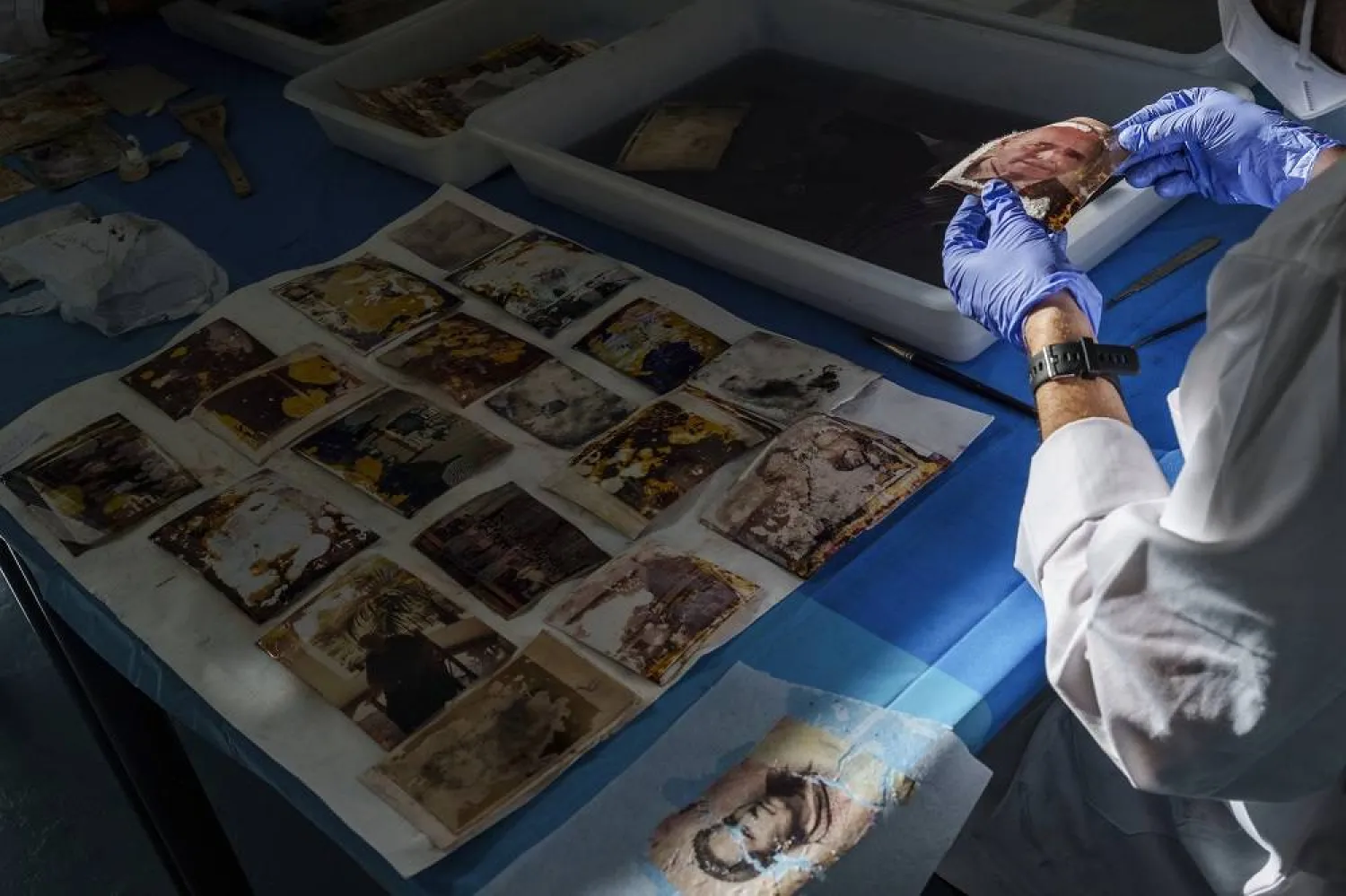
Water-stained and splotched with mud, the photos have an abstract quality to them. Neon pinks, yellows and blues have replaced the faded tones of old photo albums and the browns and sepia tones of negatives. Many are hard to decipher but for the odd caption preserved in marker.

But outlines of faces and memories remain even in the most damaged pictures.

"Summer, 1983," reads one photo caption that shows a trip to a river in eastern Spain. Little else remains of the picture besides swirls of purple. Others are more intact, like the photo of an older woman glancing at an angle toward the camera, a portrait that evokes another era.

The restoration process starts with volunteers registering each photo and taking pictures of them, including to record how they were arranged in an album. Then, each image is cleaned in shallow bins of water. Later, they are hung to dry and mounted on a special paper, before they are returned alongside a digital copy.

Many Valencians who survived the floods, Spain’s worst natural disaster in recent memory, learned about the project by word of mouth. Some say it has helped them not lose their own history.

"When you realize how much you’ve lost, you can see that you’ve lost something fundamental, like visual memories," said Isabel Cordero, a retirement-aged resident who survived the floods but lost all her possessions in a ground-floor apartment in the hard-hit town of Aldaia. She said she will never forget the calls for help that she heard at night or the arrival of volunteers who brought water and milk after the tsunami-like waves swept through her neighborhood.

On a recent January morning, Cordero collected a brown paper bag from the university filled with photos that had been cleaned. She flipped through memories from decades past, when her children were young and when she herself was college-aged.

The project, a tearful Cordero said, gave back an "emotional wealth."

"It’s something that cannot be reconstructed or recovered in any other way," she said.

Others are still waiting to see the photos they handed over to the photography students, who have received 230,000 photos and 1,800 albums. The project's organizers want to get to every photo by the one-year anniversary of the floods, but Nebot said they will not turn anyone away who comes with more albums.

That could mean not finishing by late October, Nebot said, as the time it takes to clean a picture depends on how damaged it is coming in. Many photos stayed soaked for weeks, with their owners salvaging what they could.


Saudi Arabia Reaffirms Commitment to Environmental Action on Saudi Green Initiative Day

One of the mountainous areas located in the south of the Kingdom of Saudi Arabia (Asharq Al-Awsat)
TT

Saudi Arabia Reaffirms Commitment to Environmental Action on Saudi Green Initiative Day

One of the mountainous areas located in the south of the Kingdom of Saudi Arabia (Asharq Al-Awsat)

The Saudi Green Initiative (SGI) Day, observed annually on March 27 following a Cabinet decision, reflects the Kingdom's commitment to establishing a culture of sustainability, enhancing national environmental efforts, and encouraging all sectors to achieve sustainable development goals in line with Vision 2030, SPA reported.

The initiative recently achieved a significant national milestone by rehabilitating one million hectares of degraded land through the National Greening Program, overseen by the National Center for Vegetation Cover Development and Combating Desertification. This objective aims to expand vegetation cover, reduce desertification, improve quality of life, and enhance the natural capacity of local environments to adapt to climate change.

The achievement is an extension of the Kingdom's broader efforts to protect natural resources, reduce emissions, promote reliance on clean energy, and preserve biodiversity, thereby strengthening Saudi Arabia's regional and international standing in environmental action.

Over the past year, the initiative has continued to make tangible progress. More than 159 million trees were planted across the Kingdom, and environmental reserves saw the birth of Arabian oryx calves for the third consecutive year. Furthermore, the National Water Efficiency and Conservation Center currently saves 120,000 cubic meters of water daily, with plans to increase this capacity to 300,000 cubic meters.

These combined efforts align with the objectives of Vision 2030 and contribute to strengthening the Kingdom’s regional and international standing in environmental sustainability.

SGI Day is observed annually to highlight the initiative’s achievements, review its future goals, and encourage broad sector participation in environmental efforts and sustainable development.

These efforts reflect the Kingdom’s approach to environmental and climate action, driven by the Saudi Green Initiative and the Middle East Green Initiative, both launched by Prince Mohammed bin Salman bin Abdulaziz Al Saud, Crown Prince and Prime Minister, underscoring its ongoing commitment to supporting the transition toward a more sustainable development model.


Satellite Observations Offer Insight into a Tsunami’s Early Stages

A person shows a cell phone displaying a message to evacuate to a tsunami safety zone during an evacuation of the coast following a tsunami warning issued by local authorities after an earthquake struck the Kamchatka Peninsula in the far east of Russia, triggering warnings and evacuations across the South Pacific, in Dichato, near Concepcion, Chile, July 30, 2025. (Reuters)
TT

Satellite Observations Offer Insight into a Tsunami’s Early Stages

A person shows a cell phone displaying a message to evacuate to a tsunami safety zone during an evacuation of the coast following a tsunami warning issued by local authorities after an earthquake struck the Kamchatka Peninsula in the far east of Russia, triggering warnings and evacuations across the South Pacific, in Dichato, near Concepcion, Chile, July 30, 2025. (Reuters)

Observations made by a satellite operated by the US and French space agencies shortly after a strong earthquake struck off Russia's Kamchatka Peninsula last year are giving scientists a better understanding of how tsunamis originate and propagate.

The researchers said the findings may help improve understanding of future tsunamis and earthquakes at subduction zones, particularly near the ocean trench where two tectonic plates meet and one slides beneath the other. The strongest tsunamis often are generated by such quakes.

The magnitude 8.8 quake struck on July 29, 2025, triggering a tsunami that spread across the Pacific Ocean. A tsunami - a series of extremely long and powerful ocean waves - is caused by large movements of the seafloor that push water up or down, often during earthquakes or landslides that occur under water.

The NASA-CNES Surface Water and Ocean Topography, or SWOT, satellite ‌made its observations ‌within 70 minutes of the start of the earthquake. It observed not ‌only ⁠the leading wave ⁠of the tsunami, but also a distinct pattern of smaller waves trailing behind it.

Such wave patterns had long been predicted in computer models and theoretical studies, but had been difficult to confirm with real-world observations, the researchers said.

"I believe SWOT represents a new lens for observing and studying tsunamis and their generation," said Ignacio Sepúlveda, a professor of coastal engineering at San Diego State University and lead author of the study published this week in the journal Science.

"It is also likely to improve our understanding of the physical mechanisms that generate tsunamis, including earthquakes," ⁠Sepúlveda added.

Traditional deep-ocean pressure sensors and other satellites have limitations in coverage ‌and measurement, making it difficult to capture the full structure of ‌the waves, especially near the trench, the researchers said.

SWOT scans a wide swath of the ocean, producing two-dimensional maps ‌of sea surface height. This allows scientists to see the shape, direction and spacing of tsunami waves ‌in much greater detail.

Tsunamis are among the strongest and most destructive natural forces, with powerful waves radiating from a point of origin outward in all directions. These waves can cause damaging and deadly coastal flooding.

The tsunami in this study did not cause significant loss of life, but others have caused huge death tolls such as the 2004 Indian Ocean ‌tsunami that killed some 230,000 people.

The July 2025 tsunami originated within about 10 kilometers (six miles) of the trench, the place in the seafloor ⁠where two tectonic plates intersect, ⁠the researchers found. This location could not previously be determined using traditional land-based instruments or sparse sensors on the seafloor alone.

Earth's surface is made up of immense plates that move very gradually in a geological process called plate tectonics.

The researchers found that when earthquake-caused movement extends close to the trench, it can generate shorter waves that travel more slowly and spread out over time, forming a trailing pattern behind the main tsunami front. This behavior means that different parts of the wave move at different speeds, with longer waves moving more quickly and leading, while shorter ones lag behind.

The study also showed that the strength of the trailing waves increases when earthquake movement extends closer to the trench, suggesting these waves are linked to where and how the tsunami was generated near the trench.

"This opens a new window to understand in a better way what happens with earthquakes and tsunamis near the trench," Sepúlveda said, referring to SWOT observations. "In the future, this knowledge will allow us to improve models we use to evaluate tsunami hazards in coastal communities and make them more resilient."


Gabon Battles for Baby Sea Turtles’ Survival

 An olive ridley sea turtle hatchling moves on a beach after emerging from its nest near Libreville on February 15, 2026. (AFP)
An olive ridley sea turtle hatchling moves on a beach after emerging from its nest near Libreville on February 15, 2026. (AFP)
TT

Gabon Battles for Baby Sea Turtles’ Survival

 An olive ridley sea turtle hatchling moves on a beach after emerging from its nest near Libreville on February 15, 2026. (AFP)
An olive ridley sea turtle hatchling moves on a beach after emerging from its nest near Libreville on February 15, 2026. (AFP)

Small enough to fit in the palm of your hand, newly hatched sea turtles emerged on a Gabonese beach to embark on the treacherous 10-meter (33-foot) scramble across the sand to the ocean.

"The survival rate for turtles is one in 1,000," Francois Boussamba, a Gabonese turtle expert and head of the NGO Aventures Sans Frontieres (Adventures Without Borders), told AFP, scouring for nests.

Conservationists from NGOs and the national parks agency patrol Gabon's beaches daily during the nesting season to protect the turtles' nests.

Those under threat are moved to a hatchery, a fenced enclosure near the sea, where the eggs are kept safe until they are ready to hatch.

On Pongara National Park's white sandy beaches, about 30 minutes by boat from the capital Libreville, conditions are optimal for nesting: wild coastline, a favorable equatorial climate and an open ocean beach with gentle slopes, ideal for the females.

But dangers lurk. Nests are threatened by coastal erosion due to encroaching sea levels, or myriad predators such as crabs and birds that prevent the eggs from reaching their 60-day incubation period, Boussamba said.

"The chances of survival are tiny," he said.

- Muscle up -

In Libreville, every morning around 7:00 am, volunteers from the Project Turtles Tahiti Gabon association crisscross the beach and check the nests in the hatchery.

After one has hatched, the baby turtles have to be moved so they can reach the sea -- but they are never put straight into the water.

"They need to build up their muscles so they can swim in the ocean," volunteer Clemence said.

Four species of turtles -- green, olive ridley, hawksbill and leatherback -- come to nest along Gabon's 900 kilometers (560 miles) of coastline from October to April.

It has the highest nesting density on the African continent, according to the US-based NGO Wildlife Conservation Society.

Gabon is the world's leading nesting site for the leatherback turtle, the largest of the species and listed as threatened by the International Union for Conservation of Nature (IUCN).

In addition to predators, sea turtles are also threatened by human activities, from plastic pollution to industrial fishing and poachers.

By watching over the eggs, the rangers in Pongara help ensure "the survival of this species", Edouard Moussavou, Pongara park's deputy director, said.

- Unpaid wages -

Since 2013, Gabon's conservation efforts had received funding from the United States, notably through the US Fish and Wildlife Service, an agency responsible for biodiversity.

"If there are turtles, it means our ecosystem is sound and healthy," Boussamba said.

But since the suspension of grants by the administration of US President Donald Trump, "turtle monitoring activities have stopped or slowed down drastically", Moussavou said.

"There will be fewer staff, less data, and that really creates difficulties for us," he said.

Additionally, there have been delays in paying the staff of the National Agency for National Parks (ANPN), which manages the country's 13 parks, according to Sosthene Ndong Engonga, secretary-general of the National Union of Gabonese Ecoguards.

The around 580 eco-rangers regularly go unpaid.

"Even when there is money, we have to make a big fuss to get our salaries," he said, adding he battled with the treasury last month for back pay.

The eco-rangers, who are crucial for the conservation of Gabon's biodiversity, face having "to give everything up," Engonga warned. "We have expenses we can no longer cover," he said.

On Pongara beach, 40-year-old Alain Banguiya carries out night patrols, hoping to see a leatherback turtle emerge from the water to lay her eggs in the sand.

An eco-ranger since 2015, he has not been paid for two months but says that giving up is out of the question.

"We have a duty to fight to the end, to keep our spirits up," he said. "Despite the obstacles, we stay the course: conservation."