


Report: Amazon Fires Drive Unprecedented Global Forest Loss in 2024

A firefighter sets the forest ablaze as part of a controlled plan to prevent wildfires in the Cerrado region, at a national park in Brasilia, Brazil, Tuesday, May 20, 2025. (AP Photo/Eraldo Peres)
TT

Report: Amazon Fires Drive Unprecedented Global Forest Loss in 2024

A firefighter sets the forest ablaze as part of a controlled plan to prevent wildfires in the Cerrado region, at a national park in Brasilia, Brazil, Tuesday, May 20, 2025. (AP Photo/Eraldo Peres)

Massive fires fueled by climate change led global forest loss to smash records in 2024, according to a report issued on Wednesday.

Loss of tropical pristine forests alone reached 6.7 million hectares (16.6 million acres), an 80% spike compared to 2023 and an area roughly the size of Panama, mainly because Brazil, the host of the next global climate summit in November, struggled to contain fires in the Amazon amid the worst drought ever recorded in the rainforest. A myriad of other countries, including Bolivia and Canada, were also ravaged by wildfires.

It was the first time the annual report, issued by the World Resources Institute and the University of Maryland, showed fires as the leading cause of tropical forest loss, a grim milestone for a naturally humid ecosystem that is not supposed to burn, Reuters reported.

"The signals in these data are particularly frightening," said Matthew Hansen, the co-director of a lab at the University of Maryland that compiled and analyzed the data. "The fear is that the climate signal is going to overtake our ability to respond effectively."

Latin America was hit particularly hard, the report said, with the Amazon biome hitting its highest level of primary forest loss since 2016.

Brazil, which holds the largest share of the world's tropical forests, lost 2.8 million hectares (6.9 million acres), the most of any country. It was a reversal of the progress made in 2023 when President Luiz Inacio Lula da Silva took office promising to protect the world's largest rainforest.

“This was unprecedented, which means we have to adapt all our policy to a new reality,” said Andre Lima, who oversees deforestation control policies for Brazil’s Ministry of Environment, adding that fire, which was never among the leading causes of forest loss, is now a top priority for the government.

Bolivia overtook the Democratic Republic of Congo as the second country with the most tropical forest loss despite having less than half the amount of forest as the African nation, which also saw a spike in forest loss last year.

Bolivia's forest loss surged by 200% in 2024, with a drought, wildfires and a government-incentivized agricultural expansion as the leading causes. Across Latin America, the report noted similar trends in Mexico, Peru, Nicaragua, and Guatemala.

Conflicts in Colombia and the Democratic Republic of Congo also boosted deforestation rates, as armed groups used up natural resources.

Outside the tropics, boreal forests, which evolved with seasonal fires, also posted record-high tree loss in 2024, with Canada and Russia each losing 5.2 million hectares (12.8 million acres) in 2024 as wildfires got out of control.

Southeast Asia bucked the global trend with Malaysia, Laos, and Indonesia all posting double-digit decreases in primary forest loss, as domestic conservation policy, combined with efforts by communities and the private sector, continued to effectively contain fires and agricultural expansion.

Another outlier was the Charagua Iyambae Indigenous territory in southern Bolivia, which was able to keep the country's record fires at bay through land-use policies and early warning systems.

Rod Taylor, the global director for forests at the WRI, said that as leaders descend on the Amazonian city of Belem for the next climate summit, he would like to see countries make progress in introducing better funding mechanisms for conservation.

"At the moment," he said, "there's more money to be paid by chopping forests down than keeping them standing."


South Korea Issues 1st Emergency Heatwave Warning Under New Rating System

A woman uses a fan to shelter from the sun on a street in Seoul on July 12, 2026. (Photo by JADE GAO / AFP)
TT

South Korea Issues 1st Emergency Heatwave Warning Under New Rating System

A woman uses a fan to shelter from the sun on a street in Seoul on July 12, 2026. (Photo by JADE GAO / AFP)

South Korea issued its first-ever emergency heatwave alert on Sunday under a new warning system launched this year, advising people to halt outdoor activities and keep cool.

The new warning system was introduced to better deal with a rising number of heatwaves in South Korea, which have become longer and more intense, officials said.

An emergency alert is issued when areas experiencing a heatwave are forecast to hit perceived temperatures of 38C or an actual temperature of 39C for one day.

"The Korea Meteorological Administration issued an Emergency Heatwave Warning at 10 am today (GMT 0100) for two cities in southern North Gyeongsang Province -- Gyeongsan and Pohang," said agency chief Lee Mi-seon at a press briefing.

"This marks the first time it has been issued since the system took effect," she added, according to AFP.

The affected areas saw temperatures reach the emergency criteria over the weekend.

"An emergency heatwave warning does not simply mean the weather is extremely hot," Lee said.

"It indicates conditions in which even healthy people face a significantly elevated risk of serious harm, including heat-related illness and death."

People engaged in outdoor activities should stop immediately and move to a cool place, and no one, including children or pets, should be left inside a vehicle, she added.

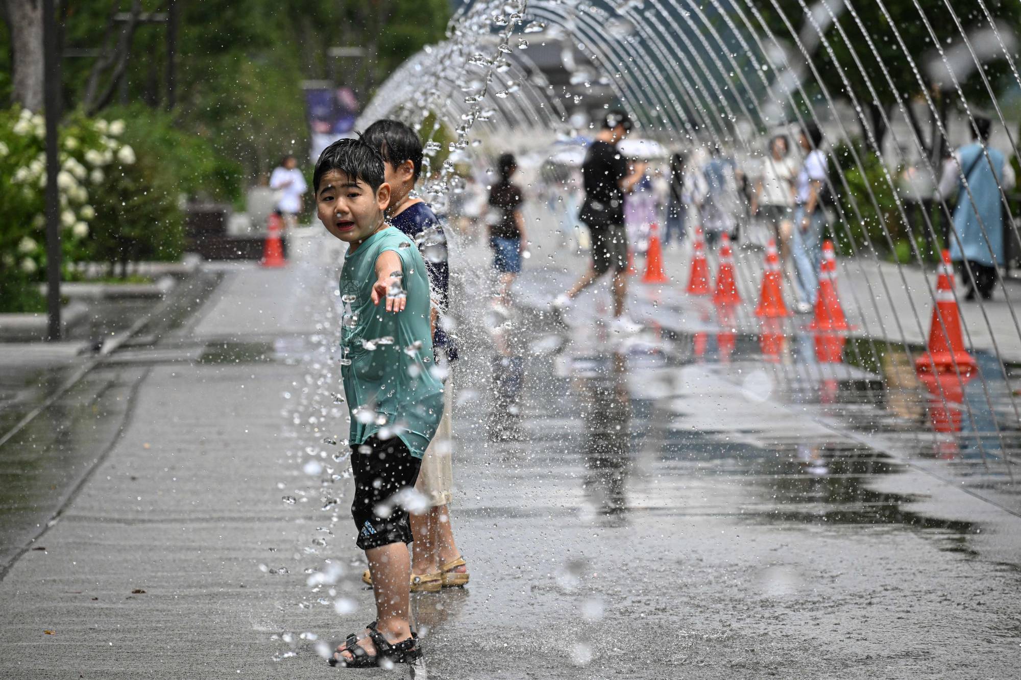
A child plays in a fountain tunnel to cool off at Gwanghwamun Square in Seoul on July 12, 2026. (Photo by JADE GAO / AFP)

Much of the country -- including parts of Seoul -- remained under heatwave warnings, which are issued when the perceived temperature is expected to stay at 35C or higher for two consecutive days.

Such warnings take both temperature and humidity into account, according to the KMA.

Children tried to cool off from the heat on Sunday by running through the water jets at Gwanghwamun Square in central Seoul, an AFP reporter saw.

People also sought refuge in air-conditioned shopping malls.

KMA data show the average annual number of heatwave days in the country has more than doubled to 19 over the past five years, from eight in the 1970s.

The average annual number of tropical nights has also jumped from four to 14 over the same period.

A heatwave day is defined as one with a maximum temperature of at least 33C, while a tropical night is one when the overnight low remains 25C or above.

The new system comes as Europe endures a scorching summer, after a June heatwave shattered temperature records across the continent.

Scientists warn that extreme weather events such as heatwaves are becoming more frequent and intense as a result of human-induced climate change.


In Sicily, Drones at Work to Predict Volcanic Eruptions

Vulcanologists collect data from gas emissions with a drone and a laser during a mission in the crater of La Fossa, on Vulcano Island, one of the seven islands of the Aeolian Archipelago of Sicily, on July 9, 2026. (Photo by Marco Bertorello / AFP)
TT

In Sicily, Drones at Work to Predict Volcanic Eruptions

Vulcanologists collect data from gas emissions with a drone and a laser during a mission in the crater of La Fossa, on Vulcano Island, one of the seven islands of the Aeolian Archipelago of Sicily, on July 9, 2026. (Photo by Marco Bertorello / AFP)

Hovering over the volcano, a buzzing drone pauses in front of a laser beam on the crater's edge, as researchers test whether the devices can measure gases to predict eruptions.

On the Aeolian island of Vulcano, off the coast of Sicily, German researcher Marius Schaab, from the Technical University of Munich (TUM), stands next to a gas sensor mounted on a tripod, waiting for the drone his colleague has just launched to draw closer.

In this remote lunar landscape, where hot volcanic gases and steam smelling of sulphur rise eerily from the earth, the small propeller-driven device catches the eye.

The last eruption of the island's Grand Crater occurred in the late 19th century but the volcano continues to show intense degassing activity -- to the awe of the visitors who are allowed to walk around the rim.

Soon, the drone positions itself along the axis of the sensor, which transmits an invisible laser beam that passes through the volcanic gas emissions before being reflected by the drone, and travelling back.

The sensor works by "sending a laser beam through some gas and then onto some reflector that measures the intensity of the driving light", Schaab said.

The drone can move around and switch angles to take full measurements.

Using a laser allows the sensor to avoid the gas plume, the researcher told AFP.

"Our drone flies behind the plume and also our ground unit is not in the plume," said Schaab, noting that the corrosive nature of the plume would require any sensor inside it to be constantly recalibrated.

Based on the signals sent back to the sensor, an algorithm calculates a map of gas concentration in the 10 or 15 minutes it takes for the drone to follow a predefined path at a distance of up to 60 meters (nearly 200 feet).

Although drones have been used in monitoring volcanoes for about 15 years, scientists are now looking to develop gas measurement tools that are increasingly accurate and risk-free.

Further around the crater, another team of German scientists from the University of Mainz is using sensors carried on a drone to measure concentrations of chemical substances in the air.

"One reason for measuring gases and particles is to better understand the impact of volcanic eruptions and volcanic emissions on the atmosphere," said Tjarda Roberts, a researcher at the National Centre for Scientific Research (CNRS) in Paris, who is collaborating with the Mainz team.

"Another reason is to anticipate volcanic eruptions, because the gas composition can change before an eruption occurs," she said.

The greater the pressure exerted by lava rising from inside the Earth towards the surface, the larger the amount of gas released.

It is the first time the team from TUM has tested its drone system -- which can work at altitudes up to 3,000 meters -- on a volcano.

A checklist in hand, Jonas Krajewski, a student at the Johannes Gutenberg University Mainz, checks that "Tina" -- the name given to the drone -- is ready to fly safely.

Soon, the drone weighing 2.5 kilograms (5.5 pounds) lifts into the air and heads towards the rising gases.

This time, following a predefined flight path lasting up to 40 minutes, the drone flies into the heart of the fumaroles, or vents where the gases and vapor escape and where temperatures range between 100 and 140C.

"Tina" is equipped with a series of sensors measuring gases, particles and halogens, elements like chlorine, bromine and others.

"We have a very constant output of gas... so we can have very reliable sensor data," said Krajewski.

For Roberts, one of the biggest advantages of the drone is its great flexibility and ability to move around more diluted parts of the plume and quickly switch direction if the plume suddenly changes angles.

With the drone, researchers no longer need to carefully enter the area of the gas emissions, a dangerous activity which requires the use of masks and other protection.

"Here we don't have a major risk of an imminent eruption but there are volcanoes where you can't reach the summit on foot," Roberts said.

But with a drone, "you can take measurements... without putting yourself in danger".

Skimming over rocks speckled with yellow sulphur crystals deposited by the fumaroles, "Tina" soon reappears on the horizon.

In the coming days, a new challenge awaits the drone -- Mount Etna, the 3,000-meter-high active volcano in eastern Sicily, where a new eruption has just occurred.


One Runner Gored in the Face at Spain's San Fermin Bull Run Festival

11 July 2026, Spain, Pamplona: The fifth bull run of the 2026 San Fermin Festival. Photo: Eduardo Sanz/EUROPA PRESS/dpa
TT

One Runner Gored in the Face at Spain's San Fermin Bull Run Festival

11 July 2026, Spain, Pamplona: The fifth bull run of the 2026 San Fermin Festival. Photo: Eduardo Sanz/EUROPA PRESS/dpa

A runner was gored in the face and many more were fortunate to not be seriously injured during a chaotic bull run at Spain’s San Fermin festival on Saturday.

The six bulls and accompanying steers charged through crowds of thrill-seekers who packed the narrow street course in Pamplona. The huge animals knocked down bodies to the cobblestones, and stumbling runners caused several pileups during the two-and-a-half-minute run from the pen to the bull ring where bullfighters will kill the bulls later in the day.

One runner was pierced by a horn in the face, while 12 more people needed medical treatment for an assortment of knocks, according to the University of Navarra Hospital.

A black bull broke away from the pack early in the 875-meter (957-yard) run and plowed into a group of people, smacking one full in the side of the face with a horn. It was not clear if that was the moment of the goring, The Associated Press reported.

Many runners appeared completely unaware when bulls were breathing down their necks and, instead of trying to gore them, just shoved them out of the way.

Saturday’s was the fifth morning run of the eight-day festival in northern Spain.

This year’s festival comes 100 years since the publication of Ernest Hemingway’s novel “The Sun Also Rises,” whose publication launched the San Fermin festival to international fame.

The last death at San Fermin's bull runs occurred in 2009, but gorings and broken bones are common, partly due to the large number of novice bull runners and foreign tourists who join the experienced locals.