More than 2,100 People Are Evacuated as an Indonesian Volcano Spews Clouds of Ash

Mount Ruang volcano erupts in Sitaro, North Sulawesi, on April 19, 2024. (AFP)
TT

More than 2,100 People Are Evacuated as an Indonesian Volcano Spews Clouds of Ash

Mount Ruang volcano erupts in Sitaro, North Sulawesi, on April 19, 2024. (AFP)

More than 2,100 people living near an erupting volcano on Indonesia's Sulawesi Island were evacuated Friday due to the dangers of spreading ash, falling rocks, hot volcanic clouds and the possibility of a tsunami.

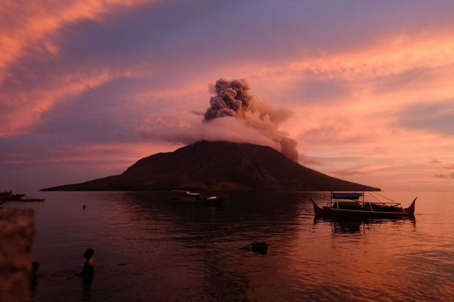
Indonesia's Center for Volcanology and Geological Hazard Mitigation recorded at least three eruptions since Friday afternoon, with the maximum height of the eruption column reaching 1,200 meters (3,900 feet).

An international airport in Manado city, less than 100 kilometers (60 miles) from the erupting Mount Ruang, is still temporarily closed as volcanic ash was spewed into the air.

Satellite imagery from the Meteorology, Climatology and Geophysics Agency shows the ash has spread to the west, northwest, northeast and southeast, covering Manado and North Minahasa, according to a statement from Indonesia’s Transportation Ministry.

“We are still monitoring developments in the eruption of Mount Ruang and coordinating with relevant stakeholders ... to anticipate the necessary actions to ensure flight safety, security and comfort,” said Ambar Suryoko, head of the regional airport authority.

More than 11,000 people were told to leave their homes that were located in the affected area. A joint team from the local authorities combed the villages surrounding the volcano and evacuated residents to safer areas by boat.

Officials worry that part of the volcano could collapse into the sea and cause a tsunami, as happened in an eruption there in 1871.

Houses, roads and other buildings were covered by gray volcanic ash, and many roofs were broken by debris spewed from the eruption.

Mount Ruang saw at least five large eruptions Wednesday, causing the Center for Volcanology and Geological Hazard Mitigation to issue its highest level of alert. People were ordered to stay at least 6 kilometers (3.7 miles) from the 725-meter (2,378-foot) mountain.

The observation from the agency on Friday said white smoke was rising from the main crater with medium to thick intensity.

East of the volcano, Tagulandang Island could be at risk if a collapse occurred. Its residents were among those being told to evacuate. Indonesia’s National Disaster Mitigation Agency said residents would be relocated to Manado, a journey of 6 hours by boat.

Indonesia, an archipelago of 270 million people, has 120 active volcanoes. It is prone to volcanic activity because it sits along the “Ring of Fire,” a horseshoe-shaped series of seismic fault lines around the Pacific Ocean.


California’s Largest Wildfire Explodes in Size as Fires Rage across US West

 A column of flame burns on a hillside during the Park Fire near Lomo, Calif., Friday, July 26, 2024. (Stephen Lam/San Francisco Chronicle via AP)
A column of flame burns on a hillside during the Park Fire near Lomo, Calif., Friday, July 26, 2024. (Stephen Lam/San Francisco Chronicle via AP)
TT

California’s Largest Wildfire Explodes in Size as Fires Rage across US West

 A column of flame burns on a hillside during the Park Fire near Lomo, Calif., Friday, July 26, 2024. (Stephen Lam/San Francisco Chronicle via AP)
A column of flame burns on a hillside during the Park Fire near Lomo, Calif., Friday, July 26, 2024. (Stephen Lam/San Francisco Chronicle via AP)

California's largest active fire exploded in size on Friday evening, growing rapidly amid bone-dry fuel and threatening thousands of homes as firefighters scrambled to meet the danger.

The Park Fire's intensity and dramatic spread led fire officials to make unwelcome comparisons to the monstrous Camp Fire, which burned out of control in nearby Paradise in 2018, killing 85 people and torching 11,000 homes.

More than 130 structures have been destroyed by this fire so far, and thousands more are threatened as evacuations were ordered in four counties — Butte, Plumas, Tehama and Shasta. It stood at 374 square miles (967 square kilometers) on Friday night and was moving quickly north and east after igniting Wednesday when authorities said a man pushed a burning car into a gully in Chico and then calmly blended in with others fleeing the scene.

"There’s a tremendous amount of fuel out there and it’s going to continue with this rapid pace," Cal Fire incident commander Billy See said at a briefing. He said the fire was advancing up to 8 square miles (21 square kilometers) an hour on Friday afternoon.

Officials at Lassen Volcanic National Park evacuated staff from Mineral, a community of about 120 people where the park headquarters are located, as the fire moved north toward Highway 36 and east toward the park.

Communities elsewhere in the US West and Canada were under siege Friday, from a fast-moving blaze sparked by lightning sent people fleeing on fire-ringed roads in rural Idaho to a new blaze that was causing evacuations in eastern Washington.

In eastern Oregon, a pilot was found dead in a small air tanker plane that crashed while fighting one of the many wildfires spreading across several Western states.

More than 110 active fires covering 2,800 square miles (7,250 square kilometers) were burning in the US on Friday, according to the National Interagency Fire Center. Some were caused by the weather, with climate change increasing the frequency of lightning strikes as the region endures record heat and bone-dry conditions.

The fire in eastern Washington was threatening homes, the railroad, Interstate 90 and the community of Tyler, which was evacuated Friday. The Columbia Basin fire in Spokane County closed part of Highway 904 between the interstate and Cheney. Multiple planes, helicopters and fire personnel were working hard to contain the fire, according to the Washington State Patrol.

In Chico, California, Carli Parker is one of hundreds who fled their homes as the Park Fire pushed close. Parker decided to leave her Forest Ranch residence with her family when the fire began burning across the street. She has previously been forced out of two homes by fire, and she said she had little hope that her residence would remain unscathed.

"I think I felt like I was in danger because the police had come to our house because we had signed up for early evacuation warnings, and they were running to their vehicle after telling us that we need to self-evacuate and they wouldn’t come back," said Parker, a mother of five.

Ronnie Dean Stout, 42, of Chico, was arrested early Thursday in connection with the blaze and held without bail pending a Monday arraignment, officials said. There was no reply to an email to the district attorney asking whether the suspect had legal representation or someone who could comment on his behalf.

Fire crews were making progress on another complex of fires burning in the Plumas National Forest near the California-Nevada line, said Forest Service spokesperson Adrienne Freeman. Most of the 1,000 residents evacuated by the lightning-sparked Gold Complex fires were returning home Friday. Some crews were peeling off to help battle the Park Fire.

"As evidenced by the (Park) fire to the West, some of these fires are just absolutely exploding and burning at rates of spread that it is just hard to even imagine," Tim Hike, Forest Service incident commander of the Gold Complex fire about 50 miles (80 km) northwest of Reno, said Friday. "The fire does not look that bad right up until it does. And then that just might be too late."

Forest Ranch evacuee Sherry Alpers, fled with her 12 small dogs and made the decision to stay in her car outside a Red Cross shelter in Chico after learning that animals would not be allowed inside. She ruled out traveling to another shelter after learning the dogs would be kept in cages, since her dogs have always roamed free at her home.

Alpers said she doesn’t know whether the fire spared her home or not, but she said that as long as her dogs are safe, she doesn't care about the material things.

"I’m kind of worried, but not that much," she said. "If it’s gone, it’s gone."

Brian Bowles was also staying in his car outside the shelter with his dog Diamon. He said he doesn't know if his mobile home is still standing.

Bowles said he only has a $100 gift card he received from United Way, which handed them out to evacuees.

"Now the question is, do I get a motel room and comfortable for one night? Or do I put gas in the car and sleep in here?" he said. "Tough choice."

In Oregon, a Grant County Search and Rescue team on Friday morning located a small single-engine air tanker that had disappeared while fighting the 219-square-mile (567 square kilometers) Falls Fire burning near the town of Seneca and the Malheur National Forest. The pilot died, said Bureau of Land Management information officer Lisa Clark. No one else was aboard the bureau-contracted aircraft when it went down in steep, forested terrain.

The most damage so far has been to the Canadian Rockies’ Jasper National Park, where a fast-moving wildfire forced 25,000 people to flee and devastated the park’s namesake town, a World Heritage site.

In Idaho, lightning strikes sparked fast-moving wildfires and the evacuation of multiple communities. The fires were burning on about 31 square miles (80 square kilometers) Friday afternoon.

Videos posted to social media include a man who said he heard explosions as he fled Juliaetta, about 27 miles (43 kilometers) southeast of the University of Idaho’s campus in Moscow. The town of just over 600 residents was evacuated Thursday just ahead of roaring fires, as were several other communities near the Clearwater River and the Nez Perce Tribal Hatchery Complex, which breeds salmon.

There’s no estimate yet on the number of buildings burned in Idaho, nor is there information about damage to urban communities, officials said Friday morning.

Oregon still has the biggest active blaze in the United States, the Durkee Fire, which combined with the Cow Fire to burn nearly 630 square miles (1,630 square kilometers). It remains unpredictable and was only 20% contained Friday, according to the government website InciWeb.

The National Interagency Fire Center said more than 27,000 fires have burned more than 5,800 square miles (15,000 square kilometers) in the US this year, and in Canada, more than 8,000 square miles (22,800 square kilometers) have burned in more than 3,700 fires so far, according to its National Wildland Fire Situation Report issued Wednesday.