From Guardrails to Potholes, AI is Becoming the New Eyes on America’s Roads

Chelsea Palacio, public information manager for the City of San Jose, showcases how a small detection camera uses AI to detect road hazards and potholes, in San Jose, Calif., Wednesday, Nov. 12, 2025. (AP Photo/Godofredo A. Vásquez)
TT

From Guardrails to Potholes, AI is Becoming the New Eyes on America’s Roads

Chelsea Palacio, public information manager for the City of San Jose, showcases how a small detection camera uses AI to detect road hazards and potholes, in San Jose, Calif., Wednesday, Nov. 12, 2025. (AP Photo/Godofredo A. Vásquez)

As America’s aging roads fall further behind on much-needed repairs, cities and states are turning to artificial intelligence to spot the worst hazards and decide which fixes should come first.

Hawaii officials, for example, are giving away 1,000 dashboard cameras as they try to reverse a recent spike in traffic fatalities. The cameras will use AI to automate inspections of guardrails, road signs and pavement markings, instantly discerning between minor problems and emergencies that warrant sending a maintenance crew, said The Associated Press.

“This is not something where it’s looked at once a month and then they sit down and figure out where they’re going to put their vans,” said Richard Browning, chief commercial officer at Nextbase, which developed the dashcams and imagery platform for Hawaii.

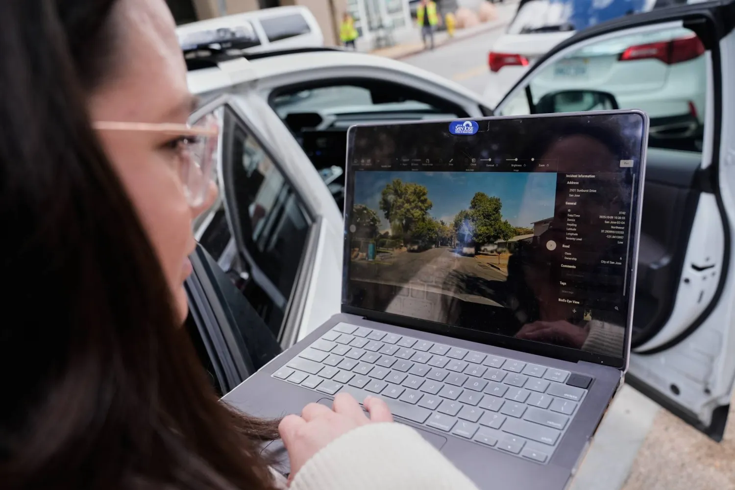
After San Jose, California, started mounting cameras on street sweepers, city staff confirmed the system correctly identified potholes 97% of the time. Now they're expanding the effort to parking enforcement vehicles.

Texas, where there are more roadway lane miles than the next two states combined, is less than a year into a massive AI plan that uses cameras as well as cellphone data from drivers who enroll to improve safety.

Other states use the technology to inspect street signs or build annual reports about road congestion.

Every guardrail, every day Hawaii drivers over the next few weeks will be able to sign up for a free dashcam valued at $499 under the “Eyes on the Road” campaign, which was piloted on service vehicles in 2021 before being paused due to wildfires.

Roger Chen, a University of Hawaii associate professor of engineering who is helping facilitate the program, said the state faces unique challenges in maintaining its outdated roadway infrastructure.

“Equipment has to be shipped to the island,” Chen said. “There’s a space constraint and a topography constraint they have to deal with, so it’s not an easy problem.”

Although the program also monitors such things as street debris and faded paint on lane lines, the companies behind the technology particularly tout its ability to detect damaged guardrails.

“They’re analyzing all guardrails in their state, every single day,” said Mark Pittman, CEO of Blyncsy, which combines the dashboard feeds with mapping software to analyze road conditions.

Hawaii transportation officials are well aware of the risks that can stem from broken guardrails. Last year, the state reached a $3.9 million settlement with the family of a driver who was killed in 2020 after slamming into a guardrail that had been damaged in a crash 18 months earlier but never repaired.

In October, Hawaii recorded its 106th traffic fatality of 2025 — more than all of 2024. It's unclear how many of the deaths were related to road problems, but Chen said the grim trend underscores the timeliness of the dashboard program.

Building a larger AI database San Jose has reported strong early success in identifying potholes and road debris just by mounting cameras on a few street sweepers and parking enforcement vehicles.

But Mayor Matt Mahan, a Democrat who founded two tech startups before entering politics, said the effort will be much more effective if cities contribute their images to a shared AI database. The system can recognize a road problem that it has seen before — even if it happened somewhere else, Mahan said.

“It sees, ‘Oh, that actually is a cardboard box wedged between those two parked vehicles, and that counts as debris on a roadway,’” Mahan said. “We could wait five years for that to happen here, or maybe we have it at our fingertips.”

San Jose officials helped establish the GovAI Coalition, which went public in March 2024 for governments to share best practices and eventually data. Other local governments in California, Minnesota, Oregon, Texas and Washington, as well as the state of Colorado, are members.

Some solutions are simple Not all AI approaches to improving road safety require cameras.

Massachusetts-based Cambridge Mobile Telematics launched a system called StreetVision that uses cellphone data to identify risky driving behavior. The company works with state transportation departments to pinpoint where specific road conditions are fueling those dangers.

Ryan McMahon, the company's senior vice president of strategy & corporate development, was attending a conference in Washington, D.C., when he noticed the StreetVision software was showing a massive number of vehicles braking aggressively on a nearby road.

The reason: a bush was obstructing a stop sign, which drivers weren't seeing until the last second.

“What we’re looking at is the accumulation of events,” McMahon said. “That brought me to an infrastructure problem, and the solution to the infrastructure problem was a pair of garden shears."

Texas officials have been using StreetVision and various other AI tools to address safety concerns. The approach was particularly helpful recently when they scanned 250,000 lane miles (402,000 kilometers) to identify old street signs long overdue for replacement.

“If something was installed 10 or 15 years ago and the work order was on paper, God help you trying to find that in the digits somewhere,” said Jim Markham, who deals with crash data for the Texas Department of Transportation. “Having AI that can go through and screen for that is a force multiplier that basically allows us to look wider and further much faster than we could just driving stuff around.”

Autonomous vehicles are next Experts in AI-based road safety techniques say what's being done now is largely just a stepping stone for a time when a large proportion of vehicles on the road will be driverless.

Pittman, the Blyncsy CEO who has worked on the Hawaii dashcam program, predicts that within eight years almost every new vehicle — with or without a driver — will come with a camera.

“How do we see our roadways today from the perspective of grandma in a Buick but also Elon and his Tesla?” Pittman said. “This is really important nuance for departments of transportation and city agencies. They're now building infrastructure for humans and automated drivers alike, and they need to start bridging that divide.”


Sudan's Historic Acacia Forest Devastated as War Fuels Logging

Little is left of the once sprawling acacia forest south of Sudan's capital. Ebrahim Hamid / AFP
TT

Sudan's Historic Acacia Forest Devastated as War Fuels Logging

Little is left of the once sprawling acacia forest south of Sudan's capital. Ebrahim Hamid / AFP

Vast stretches of a once-verdant acacia forest south of Sudan's capital Khartoum have been reduced to little more than fields of stumps as nearly three years of conflict have fueled deforestation.

What was once a 1,500-hectare natural reserve has been "completely wiped out", Boushra Hamed, head of environmental affairs for Khartoum state, told AFP.

Al-Sunut forest had long served as a haven for migratory birds and a vital green shield against the Nile's seasonal floods.

"During the war, Khartoum state has lost 60 percent of its green cover," Hamed said, describing how century-old trees "were cut down with electric saws" for commercial timber and charcoal production.

Where tall acacias once cast cool shade over a wetland just upstream from the confluence of the Blue and White Nile, barren ground now lies exposed, criss-crossed by people gathering whatever wood remains.

Hamed called it "methodical destruction", though the perpetrators remain unknown and there has been no investigation.

Similar devastation is unfolding across several regions -- including western Darfur, neighboring Kordofan and the central states of Sennar and Al-Jazirah -- as insecurity and economic collapse drive unchecked logging, according to Sudan's Forests National Corporation.

According to a 2019 study by the Nairobi-based African Forest Forum, Sudan had already lost nearly half of its forested land since 1960 due to agricultural expansion, firewood collection and overgrazing.

By 2015, the country ranked among Africa's least forested nations, with around 10 percent of its territory still covered by woodland, the study said.

The report had also warned of further degradation if reforestation and sustainable management efforts were not implemented -- concerns now compounded by the ongoing conflict.

- 'Barrier' -

Aboubakr Al-Tayeb, who oversees Khartoum's forestry administration, said the damage "affects not only Khartoum, but Sudan and the wider African continent."

"The forest was home to several migratory species from Europe," he told AFP.

More than a hundred bird species, including ducks, geese, terns, ibis, herons, eagles and vultures, had been recorded in the area, alongside monkeys and small mammals.

Al-Nazir Ali Babiker, an agronomist, said the loss of tree cover could cause more severe seasonal flooding because the "forest acted as a barrier" against rising waters.

Flooding strikes Sudan every year, destroying homes, farmland and infrastructure and leaving many families with no choice but to flee to safer areas.

The war in Sudan, which erupted in April 2023, has already killed tens of thousands, displaced 11 million and shattered critical infrastructure.

Before the fighting, forests supplied roughly 70 percent of Sudan's energy consumption, primarily through charcoal and firewood, according to data from the African Forest Forum.

Al-Sunut had also been a popular leisure spot for Khartoum residents.

"We used to come in groups to study and have a good time," recalls Adam Hafiz Ibrahim, a student at Omdurman Islamic University.

Today, wood gatherers have supplanted the usual walkers. Disregarding army notices alerting them to landmines, men and women traverse the dry, open ground that now stands where the ancient forest once grew.

"We're not cutting the trees. We just pick up whatever wood's already on the ground to use for the fire," said Nafisa, a woman in her forties navigating the dry grasslands.

"We found the trees down. We collect the wood to sell to bakeries and families," said Mohamed Zakaria, a construction worker who lost his job because of the war.

Experts say that the economic hardship caused by the war combined with a lack of enforcement has encouraged logging.

"The logging continues, because those responsible for forest protection cannot access many areas," said Mousa el-Sofori, head of Sudan's Forests National Corporation.

Efforts to replant acacias are underway, Tayeb of the Khartoum forestry administration said, but seedlings grow slowly and can take years to mature.

Restoring the lost woodlands would be "long and costly", said Sofori.

"Some of these forests were centuries old," he added.


Coffee Regions Hit by Extra Days of Extreme Heat, Say Scientists 

17 April 2012, North Rhine-Westphalia, Vluyn: A general view of Arabica Coffee beans. (dpa)
TT

Coffee Regions Hit by Extra Days of Extreme Heat, Say Scientists 

17 April 2012, North Rhine-Westphalia, Vluyn: A general view of Arabica Coffee beans. (dpa)

The world's main coffee-growing regions are roasting under additional days of climate change-driven heat every year, threatening harvests and contributing to higher prices, researchers said Wednesday.

An analysis found that there were 47 extra days of harmful heat per year on average in 25 countries representing nearly all global coffee production between 2021 and 2025, according to independent research group Climate Central.

Brazil, Vietnam, Colombia, Ethiopia and Indonesia -- which supply 75 percent of the world's coffee -- experienced on average 57 additional days of temperatures exceeding the threshold of 30C.

"Climate change is coming for our coffee. Nearly every major coffee-producing country is now experiencing more days of extreme heat that can harm coffee plants, reduce yields, and affect quality," said Kristina Dahl, Climate Central's vice president for science.

"In time, these impacts may ripple outward from farms to consumers, right into the quality and cost of your daily brew," Dahl said in a statement.

US tariffs on imports from Brazil, which supplies a third of coffee consumed in the United States, contributed to higher prices this past year, Climate Central said.

But extreme weather in the world's coffee-growing regions is "at least partly to blame" for the recent surge in prices, it added.

Coffee cultivation needs optimal temperatures and rainfall to thrive.

Temperatures above 30C are "extremely harmful" to arabica coffee plants and "suboptimal" for the robusta variety, Climate Central said. Those two plant species produce the majority of the global coffee supply.

For its analysis, Climate Central estimated how many days each year would have stayed below 30C in a world without carbon pollution but instead exceeded that level in reality -- revealing the number of hot days added by climate change.

The last three years have been the hottest on record, according to climate monitors.


Dog Gives Olympics Organizers Paws for Thought

A dog wanders on the ski trail during the women's team cross country free sprint qualification event of the Milano Cortina 2026 Winter Olympic Games at Tesero Cross-Country Skiing Stadium in Lago di Tesero (Val di Fiemme), on February 18, 2026. (Photo by Anne-Christine POUJOULAT / AFP)
TT

Dog Gives Olympics Organizers Paws for Thought

A dog wanders on the ski trail during the women's team cross country free sprint qualification event of the Milano Cortina 2026 Winter Olympic Games at Tesero Cross-Country Skiing Stadium in Lago di Tesero (Val di Fiemme), on February 18, 2026. (Photo by Anne-Christine POUJOULAT / AFP)

A dog decided he would bid for an unlikely Olympic medal on Wednesday as he joined the women's cross country team free sprint in the Milan-Cortina Games.

The dog ran onto the piste in Tesero in northern Italy and gamely, even without skis, ran behind two of the competitors, Greece's Konstantina Charalampidou and Tena Hadzic of Croatia.

He crossed the finishing line, his moment of glory curtailed as he was collared by the organizers and led away -- his owner no doubt will have a bone to pick with him when they are reunited.