


20,000 People Displaced by the Philippine Earthquake That Killed at Least 37

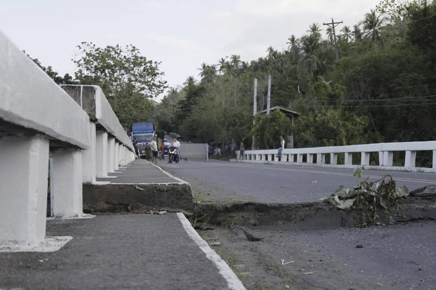
A damaged bridge closed to motor vehicles as a safety measure a day after an earthquake in Sarangani Province, southern Philippines, 09 June 2026. (EPA)
TT

20,000 People Displaced by the Philippine Earthquake That Killed at Least 37

A damaged bridge closed to motor vehicles as a safety measure a day after an earthquake in Sarangani Province, southern Philippines, 09 June 2026. (EPA)

Rescuers searched ruined buildings in the southern Philippines on Tuesday to ensure no one was still trapped a day after one of the strongest earthquakes to hit the country in a half-century killed at least 37 people and displaced more than 20,000.

Only four people were considered missing on official records in the southern provinces near where the 7.8 magnitude quake struck Monday morning, but the Office of Civil Defense acknowledged several collapsed and heavily damaged buildings must be thoroughly inspected for possible survivors or casualties.

The earthquake centered off Mindanao, the second most populous Philippine island, injured nearly 500 people and displaced more than 20,000, most of whom fled to emergency shelters.

Many people who left their homes feared a tsunami. Waves up to 1.4-meter (4.6-foot) above tide level were measured in the Philippines, but the only tsunami damage reported was to six shanties on stilts in a coastal village. Smaller waves washed ashore in Indonesia and Palau and as far away as southern Japan.

The earthquake left a trail of destruction, including in General Santos, a lively coastal city of more than 700,000 people known as the country’s tuna capital, where at least 13 people were killed in collapsed buildings and due to falling debris.

At least 18 died in Sarangani province mostly in a landslide that buried houses in the mountainside town of Glan, according to Rafaelito Alejandro of the Office of Civil Defense.

The other deaths were reported in the southern provinces of South Cotabato and Davao Occidental, and on Balut Island, disaster-response officials said.

About 2,000 houses and 117 government buildings and facilities were damaged in several provinces, according to an initial government damage assessment. The international airport in General Santos remained shut, forcing the cancellation of 63 domestic flights except for those on humanitarian mission.

About 6,000 public school buildings in quake-hit provinces must be assessed before classes can resume. The quake struck on the first day of classes nationwide after a two-month summer break and many who sustained injuries were young students who had gathered with excitement for morning flag-raising ceremonies.

Authorities have warned that buildings that sustained cracks could collapse due to aftershocks, some of them dangerously powerful.

“We cannot force the immediate reopening of schools because we have to ensure the integrity of the buildings,” Alejandro said.

Monday's earthquake was centered at sea at a depth of 33 kilometers (20 miles), about 32 kilometers (20 miles) southwest of Maasim town in Sarangani province.

It was set off by movement in the Cotabato Trench and was the strongest since the same undersea depression triggered an 8.1-magnitude quake that whipped up tsunami waves on Aug. 17, 1976, said Teresito Bacolcol, the director of the Philippine Institute of Volcanology and Seismology.

About 8,000 people died from that quake and tsunami waves of up to 8 to 10 meters (26 to 33 feet) that engulfed several towns and provinces, Bacolcol said.

The Philippine seismological institute was scheduled to commemorate the anniversary of the 1976 quake and tsunami in August by installing markers to remind vulnerable towns and cities of the need for constant vigilance, Bacolcol told The Associated Press.

A 1990 earthquake that also had a magnitude of 7.8 left more than 1,000 people dead, injured thousands and caused extensive damage in northern provinces and cities.

President Ferdinand Marcos Jr. deployed top defense-mitigation officials from Manila to help oversee search and rescue, the distribution of tens of thousands of food packs and construction materials to quake victims and assess damage to bridges, roads and other infrastructure.

The United States, a treaty ally of the Philippines, said it was coordinating with Manila and was ready to support Philippine response efforts. France, Japan and New Zealand also expressed support.

The Philippines is often hit by earthquakes and volcanic eruptions due to its location on the Pacific “Ring of Fire,” an arc of seismic faults around the ocean.

The archipelago is also battered by about 20 typhoons and tropical storms each year, making it one of the world’s most disaster-prone countries.



Google Maps Will Show ‘Lake America’ in US, not ‘Lake Ontario’

A sign reading "Lake Ontario, Now and Always," unveiled by Ontario Premier Doug Ford at Fifty Point Conservation Area, after US President Donald Trump signed an executive order renaming Lake Ontario as "Lake America," near Grimsby, Ontario, Canada, August 29, 2026. (Reuters)
TT

Google Maps Will Show ‘Lake America’ in US, not ‘Lake Ontario’

A sign reading "Lake Ontario, Now and Always," unveiled by Ontario Premier Doug Ford at Fifty Point Conservation Area, after US President Donald Trump signed an executive order renaming Lake Ontario as "Lake America," near Grimsby, Ontario, Canada, August 29, 2026. (Reuters)

Google Maps has changed the ‌name of "Lake Ontario" to "Lake America" for US users to reflect President Donald Trump's executive order renaming the lake, according to a Google statement.

Trump announced on Thursday that he was changing the name of the smallest of the five Great Lakes, part of an escalating trade feud with Canada that has prompted the two countries to impose reciprocal tariffs on billions of dollars in goods.

The president's order affects the US Geographic Names Information System (GNIS), which sets ‌the standards for ‌official US maps. It does not have ‌any ⁠impact on Canadian ⁠naming conventions or how the rest of the world refers to the lake.

"Since we update Google Maps to reflect name changes in official government sources, which is GNIS for the US, people using Maps in the US will see 'Lake America,' those in Canada will continue to see 'Lake ⁠Ontario,' and those outside of the US and ‌Canada will see both names," ‌Google said in a blog post issued on Saturday.

The White ‌House, Carney's office and Ford's office did not immediately comment ‌on Sunday on Google's decision.

Google Maps made a similar change to the Gulf of Mexico last year, labeling it the "Gulf of America" following Trump's executive order on his first day ‌in office renaming the body of water.

Canadian Prime Minister Mark Carney immediately rejected the lake's name ⁠change on ⁠Thursday. Democratic Governor Kathy Hochul of New York, which shares a long border with Canada, declared that "New York won't be calling it that," while Phil Scott, the Republican governor of neighboring Vermont, called Trump's decision "petty and disappointing" on social media.

The premier of Ontario, Doug Ford, on Saturday unveiled a large lakeside sign that reads, "Lake Ontario: Now and Always," in both English and French.

"President Trump can call it whatever he wants, but I can tell you, the rest of the world will always call it Lake Ontario," Ford said.


Trump Says US Will Refill Strategic Petroleum Reserve Using Venezuelan Oil

An oil tanker sails off the coast of Maracaibo, Venezuela, 29 August 2026. (EPA)
TT

Trump Says US Will Refill Strategic Petroleum Reserve Using Venezuelan Oil

An oil tanker sails off the coast of Maracaibo, Venezuela, 29 August 2026. (EPA)

US President Donald Trump said on Sunday that oil from a recently struck deal with Venezuela will be used to replenish the Strategic Petroleum Reserve, which has been drawn down sharply in recent years to respond to global supply disruptions ‌and high ‌fuel prices.

Trump said in ‌a ⁠social media post ⁠that the "topping out" process will begin shortly, describing the Venezuelan oil as a “Gift from Venezuela to the People of the United States.”

It is unclear ⁠how quickly the Venezuela ‌deal could ‌provide oil for the reserve or deliver ‌any near-term benefit to US motorists. ‌

The agreement Trump announced on Friday is aimed at reviving Venezuela's battered oil industry, but it will ‌require significant investment and infrastructure work before production can rise substantially.

The ⁠reserve ⁠held about 290 million barrels as of August 21, near a 44-year low, after the United States drew down its stockpile under both the Biden and Trump administrations in response to global supply disruptions, including Russia's invasion of Ukraine and the conflict with Iran.


Saved by a Lunch Break: Nepal Floods Destroyed Many Schools, but Students at This School Survived

 Mud covers the floor of a classroom damaged in the recent flash floods at the Shree Bagheswori Madhyamik School in Galchhi, Dhading district of Nepal Sunday, Aug. 30, 2026. (AP)
Mud covers the floor of a classroom damaged in the recent flash floods at the Shree Bagheswori Madhyamik School in Galchhi, Dhading district of Nepal Sunday, Aug. 30, 2026. (AP)
TT

Saved by a Lunch Break: Nepal Floods Destroyed Many Schools, but Students at This School Survived

 Mud covers the floor of a classroom damaged in the recent flash floods at the Shree Bagheswori Madhyamik School in Galchhi, Dhading district of Nepal Sunday, Aug. 30, 2026. (AP)
Mud covers the floor of a classroom damaged in the recent flash floods at the Shree Bagheswori Madhyamik School in Galchhi, Dhading district of Nepal Sunday, Aug. 30, 2026. (AP)

In one of the areas worst hit by Wednesday’s catastrophic floods in Nepal, a group of schoolchildren managed to survive when they happened to leave their classroom for their lunch break.

Children attending other classes at the school in Dhading also escaped because teachers told them to quickly evacuate their classrooms shortly before the waters came crashing in.

“The teachers said, ‘There is a flood and you should leave bags and tiffins,’” said Lakshmi Shrestha, the mother of a student attending the school. “That’s how they managed to survive.”

Shrestha was among mothers and children who began to return to their school on Sunday to find the kids' belongings and see what could be salvaged. The majority of the children at the school appeared to have survived the floods, the families said.

Thick brown and gray mud coated the surfaces of school benches, walls and notebooks while the school’s courtyard was filled with sediment. Lines on the walls showed how high the water rapidly rose. A pile of small mud-caked backpacks, some with colorful key chains, were on the benches and floors, waiting to be claimed.

Kopila Mizar, the mother of a student, was unable to find her son’s backpack, but remained positive.

“My son is alive, that is my biggest happiness,” she said.

At least 69 schools in Nepal’s flood-devastated districts have been destroyed or damaged, putting education at risk for nearly 19,000 children, according to the nonprofit Save the Children. Those numbers are likely to rise as rescue teams reach more areas, they said.

The government ordered schools and universities to shut down for three days following torrential rains that triggered severe flash floods and landslides across parts of the country. University exams were also paused.

With communities still receiving constant flood warnings advising them to move to higher, safer areas, it’s unclear when classes will be able to resume.

Nepal’s disaster agency said Sunday the death toll had climbed to 788 with 2,502 missing, while Chinese authorities reported 16 deaths and 546 missing on the Chinese side of the border.

The missing include hundreds of people from over a dozen countries who were in the region to work, visit the mountains or make a pilgrimage to a peak. On Sunday, Chinese state media said 261 foreigners were missing in Tibet, including over a hundred Nepalis and others from around the world.