Satellite Images Show Buildup on Disputed India-China Border

Satellite image shows close up view of the Line of Actual Control (LAC) border and patrol point 14 in the eastern Ladakh sector of Galwan Valley June 22, 2020. (Maxar Technologies via Reuters)
TT

Satellite Images Show Buildup on Disputed India-China Border

Satellite image shows close up view of the Line of Actual Control (LAC) border and patrol point 14 in the eastern Ladakh sector of Galwan Valley June 22, 2020. (Maxar Technologies via Reuters)

Construction activity appeared underway on both the Indian and Chinese sides of a contested border high in the Karakoram mountains a week after a deadly clash in the area left 20 Indian soldiers dead, satellite images showed.

The images released this week by Maxar, a Colorado-based satellite imagery company, show new construction activity along the Galwan River Valley, even as Chinese and Indian diplomats said military commanders had agreed to disengage from a standoff there.

The images appeared to show that the Indians had built a wall on their side and the Chinese had expanded an outpost camp at the end of a long road connected to Chinese military bases farther from the poorly defined border, according to experts.

The contradictions in words and deeds showed the fragility of an agreement following the worst violence since the Asian giants went to war in 1962 over their competing claims to the arid border region, experts said.

China has said that India first changed the status quo last August when it split the state of Jammu and Kashmir into two federal territories — the territory of Jammu and Kashmir and the territory of Ladakh, parts of which are contested by China.

The new maps released by India following the move drew criticism from Beijing because they showed Aksai Chin — an area administered by China but contested by India — as part of Ladakh.

Indian officials said the standoff that culminated in this month's deadly clash in the Galwan Valley, part of a remote stretch of the 3,380-kilometer (2,100-mile) Line of Actual Control, or LAC, established following the 1962 war, began in early May when large contingents of Chinese soldiers entered deep inside Indian-controlled territory at three places in Ladakh, erecting tents.

After a few skirmishes in May, Indian and Chinese commanders met June 6 to hash out an agreement that would reduce tensions.

The two sides agreed to build observation posts on either side of the mouth of the Galwan River, China's ambassador to India, H.E. Sun Weidong, told the Press Trust of India news agency on Tuesday.

Indian foreign ministry spokesperson Anurag Srivastava said that during the June 6 meeting "both sides had agreed to respect and abide by the LAC and not undertake any activity to alter the status quo,” but did not address whether they had agreed to observation posts.

Around midnight on June 15, soldiers attacked each other with rocks, clubs and their fists in the Galwan Valley, the deadliest violence between the two countries in 45 years.

Indian security officials said the fatalities were caused by severe injuries and exposure to subfreezing temperatures. China has not said whether it suffered any casualties in the clash.

India and China have blamed each other for the melee and staked fresh claims on the area where it occurred.

Chinese foreign ministry spokesperson Zhao Lijian said Wednesday that the confrontation occurred on China’s side of the Line of Actual Control, and that Indian forces had illegally entered Chinese territory.

“The responsibility (for the incident) is entirely not on the Chinese side,” Zhao said.

But Srivastava said Thursday that China had provoked the fight when its soldiers “sought to erect structures just across the LAC” on the Indian side. He said Indian soldiers foiled the attempts.

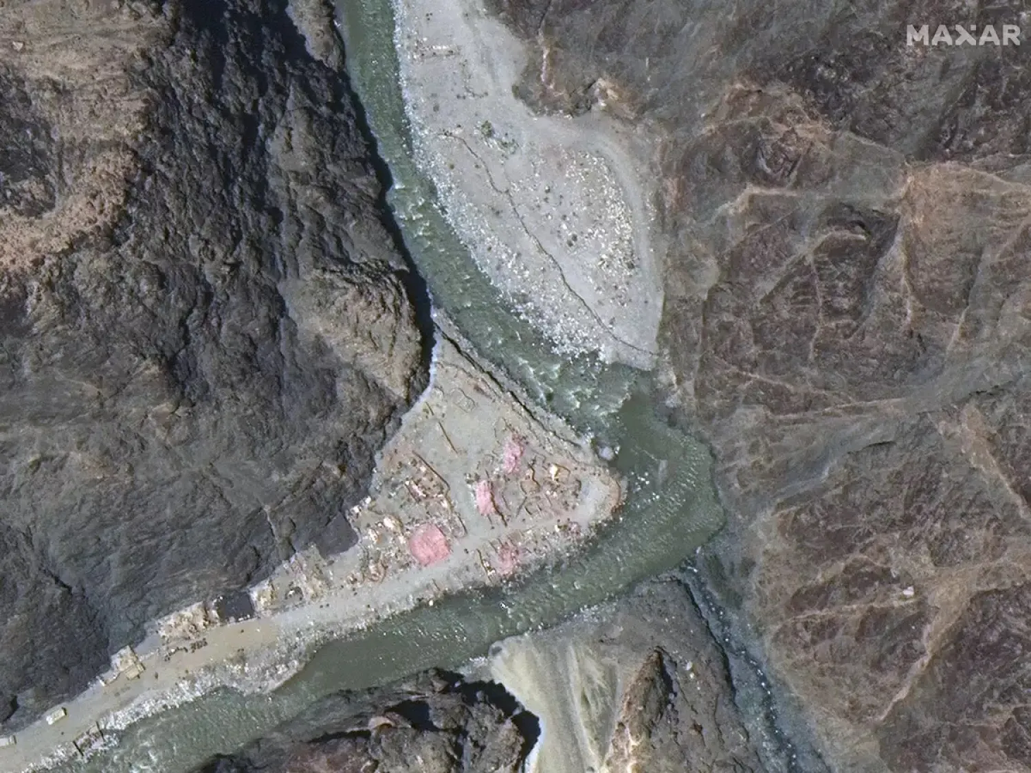
However, a sequence of Maxar images of the river bend where the clash occurred in the weeks before and after the clash showed that construction had expanded up the Galwan Valley toward the Line of Actual Control from Chinese bases, Maxar vice president Steve Wood said.

Wood said that since May 22, satellite images showed “convoy after convoy of heavy trucks, diggers, bulldozers and some military armored equipment” rolling down the Galwan Valley toward the disputed border.

Before and after the fatal clash, China was moving construction equipment, soldiers and military hardware toward the LAC, said Chris Biggers, senior analyst at the geospatial intelligence company HawkEye 360.

“The Chinese were obviously pushing toward the junction and what they perceive as their claim line. They have now built a post and a track reinforcing their claim, thus changing the status quo in the area,” he said.

At that junction, the Galwan River turns west toward an important road linked to a key Indian airfield. Biggers said that satellite imagery shows that India has built a stone wall there facing the new Chinese post, a structure that features a layered set of barriers draped in camouflage netting and tarps that “could also function as fighting positions.”

“We also see quite a bit of activity on the road, with trucks moving in both directions as well as troops marching in formation along the new track,” Biggers said.


Fighting Reaches Outskirts of Ukraine’s Stronghold Kostiantynivka

 This photograph shows a barbed wire defense line running across a field at an undisclosed location in the Kharkiv region, eastern Ukraine, on May 1, 2026, amid the Russian invasion of Ukraine. (AFP)
This photograph shows a barbed wire defense line running across a field at an undisclosed location in the Kharkiv region, eastern Ukraine, on May 1, 2026, amid the Russian invasion of Ukraine. (AFP)
TT

Fighting Reaches Outskirts of Ukraine’s Stronghold Kostiantynivka

 This photograph shows a barbed wire defense line running across a field at an undisclosed location in the Kharkiv region, eastern Ukraine, on May 1, 2026, amid the Russian invasion of Ukraine. (AFP)
This photograph shows a barbed wire defense line running across a field at an undisclosed location in the Kharkiv region, eastern Ukraine, on May 1, 2026, amid the Russian invasion of Ukraine. (AFP)

Russian troops are ‌inching towards the city of Kostiantynivka in Ukraine's eastern Donetsk region, trying to establish a foothold close to a heavily defended area, Ukraine's top army official said on Saturday.

Kostiantynivka, along with other cities, forms a so-called fortress belt in the country's east - an area well-fortified by the Ukrainian military.

"We are repelling the Russian occupiers' persistent attempts to gain a foothold in the outskirts of Kostiantynivka using infiltration tactics. Counter-sabotage measures are going on in the ‌city," Oleksandr Syrskyi, ‌Ukraine's army chief, said on the Telegram ‌app.

A ⁠Ukrainian battlefield mapping ⁠project called DeepState shows Russian troops control an area around only one kilometer (0.6 mile) from the city's southern outskirts.

Small chunks of Kostiantynivka in the southeast are marked as a grey zone, meaning neither Ukraine nor Russia has full control over them.

Russia's defense ministry said on ⁠Wednesday its forces had taken control of ‌Novodmytrivka, just north of Kostiantynivka. Moscow's ‌top general Valery Gerasimov said in April that troops were ‌advancing in the north and south of the ‌city.

Syrskyi said that Russian offensive attempts had risen noticeably in April. Since Monday, Russian troops have carried out 83 assaults in this sector using small infantry groups, he added.

Russia demands that ‌Ukraine pull back from areas in the Donetsk and neighboring Luhansk regions that it ⁠failed to capture ⁠in its four-year full-scale war. US-brokered peace talks stalled over the issue as Ukrainian officials say Kyiv will not cede land it still controls.

For the past few years, Russian troops have not managed to capture any big city agglomerations in Ukraine, inching forward and taking control over small settlements, mostly in Ukraine's east.

The small city of Pokrovsk, whose more than 60,000 pre-war population mostly fled, was the most significant gain in the past year. It took Moscow's troops months to advance, and Kyiv says it still has some positions in the city.


Report: Explosion of Bombs Left Over from Strikes Kill 14 Iranian Revolutionary Guard Members

Smoke billows from an Israeli strike on Tehran. (Reuters file)
TT

Report: Explosion of Bombs Left Over from Strikes Kill 14 Iranian Revolutionary Guard Members

Smoke billows from an Israeli strike on Tehran. (Reuters file)

An explosion of leftover bombs from strikes during the war against Iran killed 14 members of the Revolutionary Guard, Iranian media reported Friday.

A report by the Nournews website, believed to be close to Iran’s security, said the explosion happened near the northern city of Zanjan, which is northwest of Tehran.

It was the largest number of Revolutionary Guard members reported to be killed since the ceasefire began on April 7.

The report said the ammunition included cluster bombs and air mines dropped during the fighting.


US, Philippines Deploy Anti-Ship Missile System in Batanes Near Taiwan for War Games

 A vehicle used for the Navy-Marine Expeditionary Ship Interdiction System (NMESIS), stands during joint Philippine-US military exercises in Basco, Batanes province, Philippines, May 2, 2026. (Reuters)
A vehicle used for the Navy-Marine Expeditionary Ship Interdiction System (NMESIS), stands during joint Philippine-US military exercises in Basco, Batanes province, Philippines, May 2, 2026. (Reuters)
TT

US, Philippines Deploy Anti-Ship Missile System in Batanes Near Taiwan for War Games

 A vehicle used for the Navy-Marine Expeditionary Ship Interdiction System (NMESIS), stands during joint Philippine-US military exercises in Basco, Batanes province, Philippines, May 2, 2026. (Reuters)
A vehicle used for the Navy-Marine Expeditionary Ship Interdiction System (NMESIS), stands during joint Philippine-US military exercises in Basco, Batanes province, Philippines, May 2, 2026. (Reuters)

Philippine and US forces on Saturday showcased the NMESIS anti-ship missile system in Batanes province, near Taiwan, during annual war games, as tensions simmer over the self-governed island that China views as its own territory.

The Philippines' northernmost province, with about 20,000 residents, sits around 100 miles south of Taiwan, along the Luzon Strait, a strategic corridor on the frontline of the great power competition between the US and China for dominance in the Asia-Pacific region.

"Training out here in Batanes allows us a different environment than what we're normally allowed to operate in," said US Staff Sergeant Darren Gibbs.

"So it gives us unique opportunities to actually utilize the system and train within our capabilities, and it offers experiences we don't normally get offered in our day-to-day training."

Gibbs said the NMESIS is designed for remote operation, and that "the purpose of this system is for it to be ‌fully autonomous, for us ‌not to require a driver or passenger inside the vehicle itself."

"We will tell it ‌where ⁠to go and ⁠then we program what it needs to do," he said.

The NMESIS, a highly mobile coastal anti-ship missile system designed to target surface vessels from land-based positions at ranges of about 185 km (115 miles), was flown into Batanes on a US C-130 transport aircraft, and positioned in the capital Basco, which has one of the island province's two small runways.

Francisco Lorenzo, Philippine exercise director, told Reuters that deployment of US weapons such as the NMESIS to Batanes was part of efforts to test operational feasibility in remote locations. The NMESIS was also deployed to Batanes in last year's war games.

"It is part of training so ⁠as to test the feasibility or rehearse their deployment there when need arises," Lorenzo ‌said. One of the objectives of the Balikatan, as the annual "shoulder-to-shoulder" drills ‌of US and Philippine forces are called, is to practice "defense of our territory with our allies", he said.

The NMESIS would not ‌be used in live exercise operations and was brought to Batanes only for deployment rehearsal and simulation support during ‌the war games.

He said the system would be withdrawn from Batanes once the drills were finished. The US also deployed its Typhon missile system to the Philippines in 2024 for use in joint exercises.

Beijing routinely criticizes the deployment of US weapons in the Philippines, saying it heightens regional tension.

Security analyst Chester Cabalza, founder and president of the Manila-based think tank International Development and Security Cooperation, told ‌Reuters "the NMESIS can spark a powder keg for Beijing and asymmetric deterrence for Manila and Taipei in the Bashi Channel along the Luzon Strait."

The system can be ⁠airlifted and deployed to ⁠any coastline in the Philippine archipelago within hours, Cabalza said, and its placement in Batanes is likely viewed by Beijing as part of the "US-led encirclement" of China.

WAR GAMES INVOLVE 17,000 TROOPS

Philippine and US forces also carried out maritime strike drills in Itbayat, a Batanes municipality about 155 km from Taiwan and the northernmost part of the country.

More than 17,000 troops are taking part in this year's war games, including about 10,000 from the US, even as Washington remains heavily engaged in the Middle East.

China recently intensified its activities in the South China Sea and the Taiwan Strait, increasing its naval presence around Taiwan and sending an aircraft carrier through the strait. It also put up a barrier this month at the mouth of the Scarborough Shoal, according to satellite images reviewed by Reuters.

Philippine President Ferdinand Marcos Jr has said Filipinos working and living in Taiwan would have to be evacuated in the event of war over the self-governed island and that would "drag the Philippines kicking and screaming into the conflict."

Philippine Defense Secretary Gilberto Teodoro said in an April 28 interview with Reuters that Manila has a contingency plan to evacuate Filipinos in Taiwan if conflict erupts but gave no further details.