Tech-equipped Indigenous Firefighters Protect Thai Forests

Hmong volunteer firefighter Mongkol Yingyotmongkolsaen using a drone to monitor fires in the Doi Suthep-Pui National Park area of Chiang Mai. Lillian SUWANRUMPHA / AFP
TT

Tech-equipped Indigenous Firefighters Protect Thai Forests

Hmong volunteer firefighter Mongkol Yingyotmongkolsaen using a drone to monitor fires in the Doi Suthep-Pui National Park area of Chiang Mai. Lillian SUWANRUMPHA / AFP

In the dry-season heat of northern Thailand, Hmong villagers zip through forested slopes, blasting tinder with leaf blowers and cutting through brush with machetes, while others scan for smoke on live feeds from their phones.

Across about a dozen villages in the hills of Doi Suthep-Pui National Park, just above the city of Chiang Mai, Indigenous volunteers patrol on foot and clear firebreaks while also deploying drones and treetop cameras -- all to detect blazes early and defend Thailand's second-largest city from wildfire smoke, said AFP.

"The forest we protect is part of the national park -- the lungs of Chiang Mai," said Mathaphan Phuchakritdapa, who started the firefighting volunteer force a decade ago and is chief of Suthep subdistrict.

"If it burns, the city's lungs are destroyed. That's why we have to take care of it as best we can."

He and his team shifted to tech-driven firefighting after devastating wildfires in 2020 tore through the mountains above the tourism-dependent city.

The blazes lasted weeks in March and April that year, killing at least five people and injuring and displacing residents and wildlife.

The thick smoke from fires then and since has regularly pushed Chiang Mai to the top of global air pollution rankings.

- 'Worst in my life' -

Satellite imagery from the peak of the 2020 crisis showed northern Thailand blanketed by dense clusters of fire hotspots, with nearly 400 recorded in Chiang Mai province in a single day.

"It was the worst fire I've seen in my life," said Mathaphan, adding it took more than 40 days to bring it under control.

The hotter, drier weather caused by climate change creates the conditions for more frequent and destructive fires, and accumulated dry leaves can intensify them and accelerate their spread.

Outbreaks are often linked to human activities such as clearing forest and brush for foraging, hunting and agriculture.

To control air pollution, Chiang Mai authorities announced a strict five-month ban on open burning from the beginning of this year.

Authorities often blame local "hill tribes", while those communities say fires are set by outsiders for commercial purposes.

Data from NASA's fire monitoring service shows far fewer fires in the region in mid-March this year compared to the same period in 2020.

"Both local communities and state agencies are taking the issue more seriously, leading to tighter controls over burning and fire outbreaks," Mathaphan told AFP.

The Hmong, an Indigenous ethnic group originally from the mountains of southern China, have lived on these slopes in northern Thailand since migrating in the mid-20th century.

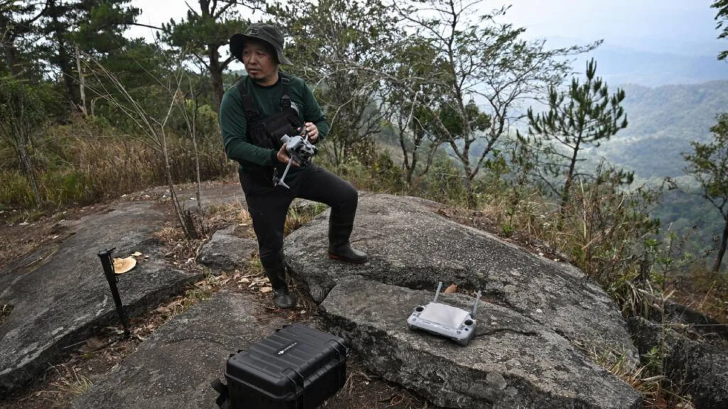
Volunteer teams roar through the hills on motorbikes, blasting away leaves with blowers and drowning out the buzz of a drone capturing footage of the blaze-prone landscape.

- 'Giving back' -

Mongkol Yingyotmongkolsaen, a 47-year-old Hmong volunteer, returned from the city three years ago and began applying his skills as a photographer to firefighting.

He installed low-cost, internet-connected video cameras high among treetops that share live feeds with villagers who can remotely monitor conditions in real time.

Mongkol also flies standard and infrared drones to monitor for fires from above, track any flames that are spreading and detect heat at night.

This allows teams to identify hotspots earlier, plan safer routes and contain fires more quickly, he said, making their work much easier.

"This is my way of giving back to my community," he added.

Across the subdistrict, each household contributes a volunteer, forming a network of about 270 people managing nearly 1,600 hectares of forest.

Monitoring this vast area requires about 1.5 million baht ($45,000) a year to cover the cost of food, fuel and equipment maintenance.

But the community receives only around 50,000 baht annually in government funding -- an amount the local chief, Mathaphan, said is insufficient.

Still, their volunteer-based approach to fire prevention has become a model for other communities, he said -- helping shift perceptions of Hmong villagers who are often blamed for deforestation and "destructive" farming practices.

"We are not destroying the forest," Mathaphan said. "We are protecting it."


Saudi Arabia Reaffirms Commitment to Environmental Action on Saudi Green Initiative Day

One of the mountainous areas located in the south of the Kingdom of Saudi Arabia (Asharq Al-Awsat)
TT

Saudi Arabia Reaffirms Commitment to Environmental Action on Saudi Green Initiative Day

One of the mountainous areas located in the south of the Kingdom of Saudi Arabia (Asharq Al-Awsat)

The Saudi Green Initiative (SGI) Day, observed annually on March 27 following a Cabinet decision, reflects the Kingdom's commitment to establishing a culture of sustainability, enhancing national environmental efforts, and encouraging all sectors to achieve sustainable development goals in line with Vision 2030, SPA reported.

The initiative recently achieved a significant national milestone by rehabilitating one million hectares of degraded land through the National Greening Program, overseen by the National Center for Vegetation Cover Development and Combating Desertification. This objective aims to expand vegetation cover, reduce desertification, improve quality of life, and enhance the natural capacity of local environments to adapt to climate change.

The achievement is an extension of the Kingdom's broader efforts to protect natural resources, reduce emissions, promote reliance on clean energy, and preserve biodiversity, thereby strengthening Saudi Arabia's regional and international standing in environmental action.

Over the past year, the initiative has continued to make tangible progress. More than 159 million trees were planted across the Kingdom, and environmental reserves saw the birth of Arabian oryx calves for the third consecutive year. Furthermore, the National Water Efficiency and Conservation Center currently saves 120,000 cubic meters of water daily, with plans to increase this capacity to 300,000 cubic meters.

These combined efforts align with the objectives of Vision 2030 and contribute to strengthening the Kingdom’s regional and international standing in environmental sustainability.

SGI Day is observed annually to highlight the initiative’s achievements, review its future goals, and encourage broad sector participation in environmental efforts and sustainable development.

These efforts reflect the Kingdom’s approach to environmental and climate action, driven by the Saudi Green Initiative and the Middle East Green Initiative, both launched by Prince Mohammed bin Salman bin Abdulaziz Al Saud, Crown Prince and Prime Minister, underscoring its ongoing commitment to supporting the transition toward a more sustainable development model.


Satellite Observations Offer Insight into a Tsunami’s Early Stages

A person shows a cell phone displaying a message to evacuate to a tsunami safety zone during an evacuation of the coast following a tsunami warning issued by local authorities after an earthquake struck the Kamchatka Peninsula in the far east of Russia, triggering warnings and evacuations across the South Pacific, in Dichato, near Concepcion, Chile, July 30, 2025. (Reuters)
TT

Satellite Observations Offer Insight into a Tsunami’s Early Stages

A person shows a cell phone displaying a message to evacuate to a tsunami safety zone during an evacuation of the coast following a tsunami warning issued by local authorities after an earthquake struck the Kamchatka Peninsula in the far east of Russia, triggering warnings and evacuations across the South Pacific, in Dichato, near Concepcion, Chile, July 30, 2025. (Reuters)

Observations made by a satellite operated by the US and French space agencies shortly after a strong earthquake struck off Russia's Kamchatka Peninsula last year are giving scientists a better understanding of how tsunamis originate and propagate.

The researchers said the findings may help improve understanding of future tsunamis and earthquakes at subduction zones, particularly near the ocean trench where two tectonic plates meet and one slides beneath the other. The strongest tsunamis often are generated by such quakes.

The magnitude 8.8 quake struck on July 29, 2025, triggering a tsunami that spread across the Pacific Ocean. A tsunami - a series of extremely long and powerful ocean waves - is caused by large movements of the seafloor that push water up or down, often during earthquakes or landslides that occur under water.

The NASA-CNES Surface Water and Ocean Topography, or SWOT, satellite ‌made its observations ‌within 70 minutes of the start of the earthquake. It observed not ‌only ⁠the leading wave ⁠of the tsunami, but also a distinct pattern of smaller waves trailing behind it.

Such wave patterns had long been predicted in computer models and theoretical studies, but had been difficult to confirm with real-world observations, the researchers said.

"I believe SWOT represents a new lens for observing and studying tsunamis and their generation," said Ignacio Sepúlveda, a professor of coastal engineering at San Diego State University and lead author of the study published this week in the journal Science.

"It is also likely to improve our understanding of the physical mechanisms that generate tsunamis, including earthquakes," ⁠Sepúlveda added.

Traditional deep-ocean pressure sensors and other satellites have limitations in coverage ‌and measurement, making it difficult to capture the full structure of ‌the waves, especially near the trench, the researchers said.

SWOT scans a wide swath of the ocean, producing two-dimensional maps ‌of sea surface height. This allows scientists to see the shape, direction and spacing of tsunami waves ‌in much greater detail.

Tsunamis are among the strongest and most destructive natural forces, with powerful waves radiating from a point of origin outward in all directions. These waves can cause damaging and deadly coastal flooding.

The tsunami in this study did not cause significant loss of life, but others have caused huge death tolls such as the 2004 Indian Ocean ‌tsunami that killed some 230,000 people.

The July 2025 tsunami originated within about 10 kilometers (six miles) of the trench, the place in the seafloor ⁠where two tectonic plates intersect, ⁠the researchers found. This location could not previously be determined using traditional land-based instruments or sparse sensors on the seafloor alone.

Earth's surface is made up of immense plates that move very gradually in a geological process called plate tectonics.

The researchers found that when earthquake-caused movement extends close to the trench, it can generate shorter waves that travel more slowly and spread out over time, forming a trailing pattern behind the main tsunami front. This behavior means that different parts of the wave move at different speeds, with longer waves moving more quickly and leading, while shorter ones lag behind.

The study also showed that the strength of the trailing waves increases when earthquake movement extends closer to the trench, suggesting these waves are linked to where and how the tsunami was generated near the trench.

"This opens a new window to understand in a better way what happens with earthquakes and tsunamis near the trench," Sepúlveda said, referring to SWOT observations. "In the future, this knowledge will allow us to improve models we use to evaluate tsunami hazards in coastal communities and make them more resilient."


Gabon Battles for Baby Sea Turtles’ Survival

 An olive ridley sea turtle hatchling moves on a beach after emerging from its nest near Libreville on February 15, 2026. (AFP)
An olive ridley sea turtle hatchling moves on a beach after emerging from its nest near Libreville on February 15, 2026. (AFP)
TT

Gabon Battles for Baby Sea Turtles’ Survival

 An olive ridley sea turtle hatchling moves on a beach after emerging from its nest near Libreville on February 15, 2026. (AFP)
An olive ridley sea turtle hatchling moves on a beach after emerging from its nest near Libreville on February 15, 2026. (AFP)

Small enough to fit in the palm of your hand, newly hatched sea turtles emerged on a Gabonese beach to embark on the treacherous 10-meter (33-foot) scramble across the sand to the ocean.

"The survival rate for turtles is one in 1,000," Francois Boussamba, a Gabonese turtle expert and head of the NGO Aventures Sans Frontieres (Adventures Without Borders), told AFP, scouring for nests.

Conservationists from NGOs and the national parks agency patrol Gabon's beaches daily during the nesting season to protect the turtles' nests.

Those under threat are moved to a hatchery, a fenced enclosure near the sea, where the eggs are kept safe until they are ready to hatch.

On Pongara National Park's white sandy beaches, about 30 minutes by boat from the capital Libreville, conditions are optimal for nesting: wild coastline, a favorable equatorial climate and an open ocean beach with gentle slopes, ideal for the females.

But dangers lurk. Nests are threatened by coastal erosion due to encroaching sea levels, or myriad predators such as crabs and birds that prevent the eggs from reaching their 60-day incubation period, Boussamba said.

"The chances of survival are tiny," he said.

- Muscle up -

In Libreville, every morning around 7:00 am, volunteers from the Project Turtles Tahiti Gabon association crisscross the beach and check the nests in the hatchery.

After one has hatched, the baby turtles have to be moved so they can reach the sea -- but they are never put straight into the water.

"They need to build up their muscles so they can swim in the ocean," volunteer Clemence said.

Four species of turtles -- green, olive ridley, hawksbill and leatherback -- come to nest along Gabon's 900 kilometers (560 miles) of coastline from October to April.

It has the highest nesting density on the African continent, according to the US-based NGO Wildlife Conservation Society.

Gabon is the world's leading nesting site for the leatherback turtle, the largest of the species and listed as threatened by the International Union for Conservation of Nature (IUCN).

In addition to predators, sea turtles are also threatened by human activities, from plastic pollution to industrial fishing and poachers.

By watching over the eggs, the rangers in Pongara help ensure "the survival of this species", Edouard Moussavou, Pongara park's deputy director, said.

- Unpaid wages -

Since 2013, Gabon's conservation efforts had received funding from the United States, notably through the US Fish and Wildlife Service, an agency responsible for biodiversity.

"If there are turtles, it means our ecosystem is sound and healthy," Boussamba said.

But since the suspension of grants by the administration of US President Donald Trump, "turtle monitoring activities have stopped or slowed down drastically", Moussavou said.

"There will be fewer staff, less data, and that really creates difficulties for us," he said.

Additionally, there have been delays in paying the staff of the National Agency for National Parks (ANPN), which manages the country's 13 parks, according to Sosthene Ndong Engonga, secretary-general of the National Union of Gabonese Ecoguards.

The around 580 eco-rangers regularly go unpaid.

"Even when there is money, we have to make a big fuss to get our salaries," he said, adding he battled with the treasury last month for back pay.

The eco-rangers, who are crucial for the conservation of Gabon's biodiversity, face having "to give everything up," Engonga warned. "We have expenses we can no longer cover," he said.

On Pongara beach, 40-year-old Alain Banguiya carries out night patrols, hoping to see a leatherback turtle emerge from the water to lay her eggs in the sand.

An eco-ranger since 2015, he has not been paid for two months but says that giving up is out of the question.

"We have a duty to fight to the end, to keep our spirits up," he said. "Despite the obstacles, we stay the course: conservation."