Feared Iran Oil Slick Smaller, May Be from Infrastructure, Says Group

This satellite image obtained from Copernicus Sentinel Data 2026 on May 8, 2026, appears to show an oil slick spreading off the coast of Kharg Island, a key oil export terminal for Iran. (Handout / Copernicus Sentinel Data 2026 / AFP)
TT

Feared Iran Oil Slick Smaller, May Be from Infrastructure, Says Group

This satellite image obtained from Copernicus Sentinel Data 2026 on May 8, 2026, appears to show an oil slick spreading off the coast of Kharg Island, a key oil export terminal for Iran. (Handout / Copernicus Sentinel Data 2026 / AFP)

Iran's oil infrastructure may be the source of a suspected slick off a key island export terminal, but satellite images showed it was "much reduced" Saturday, an environmental group said.

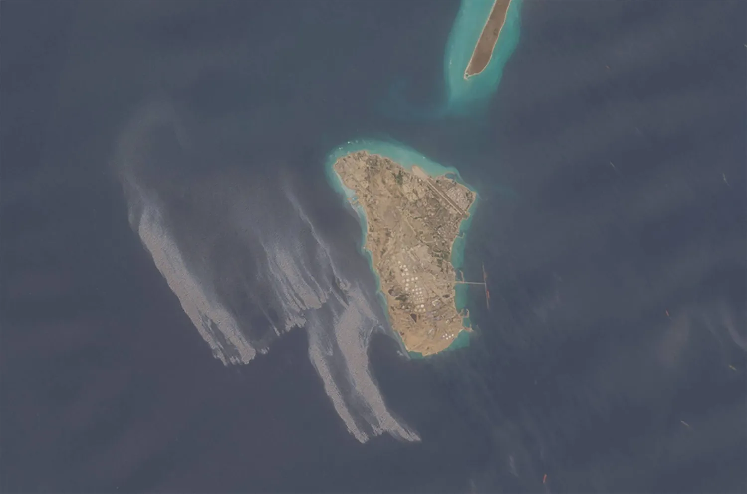
Satellite images in past days appeared to show an oil slick spreading off the coast of Iran’s Kharg Island.

It was not immediately clear what had caused the apparent spill off the west coast of the small Gulf island.

"The cause and origin of the slick remain unknown and cannot be determined conclusively from the available imagery alone," a UK-based non-governmental organization, the Conflict and Environment Observatory, told AFP.

"While offshore infrastructure in the wider area could be a potential source, we are unable to identify a definitive point of origin or attribute the spill to a specific cause at this time," said Leon Moreland from the observatory.

But he added "the slick appears visually consistent with oil based on analysis" of imagery from the Copernicus Data Space browser.

Some media reports, including by Fox News, suggested Iran's oil storage facilities may be coming under strain as a US naval blockade disrupts the country's ability to export or store crude.

Moussa Ahmadi, head of the Iranian parliament's energy commission, told ISNA news agency on Saturday there was "no official report so far confirming" that Iran's oil facility was leaking due to strained storage facilities.

"Production in various oil fields in the country continues incessantly and without any problem," he said.

Earlier, Jafar Pourkabgani, a lawmaker representing the coastal city of Bushehr, dismissed the reports as "false".

"The stains observed in satellite images around the resilient Kharg Island are related to oil and ballast water waste from oil tankers, which was dumped into the sea by a European oil tanker to the detriment of the environment," he said, according to state television.

Moreland said there was "no obvious evidence of additional active spills around the island, although the earlier slick can still be observed moving south".

Copernicus images on Saturday appeared to show that the suspected slick was "much reduced" from the first pictures seen on Wednesday, the observatory added.

It put the spread of the original slick at about 44 square kilometers (17 square miles).

But Orbital EOS, which monitors oil spills, told The New York Times the spill appeared to cover more than 20 square miles (52 square kilometers) as of Thursday.

Kharg Island is at the heart of Iran's oil export industry, a lynchpin of the country's battered economy. It sits off Iran's Gulf coast, hundreds of kilometers northwest of the narrow, strategic Strait of Hormuz.

Iran largely closed the strait at the start of its conflict with the United States and Israel on February 28. The United States has since imposed a blockade of Iranian ports. Many tankers are stranded in the area as a result of both blockades.


Russia Says Downed 419 Ukrainian Drones

A woman walks past Russian security personnel standing guard in central Moscow, Russia June 29, 2026. (Reuters)
TT

Russia Says Downed 419 Ukrainian Drones

A woman walks past Russian security personnel standing guard in central Moscow, Russia June 29, 2026. (Reuters)

Russia shot down 419 Ukrainian drones across the country overnight, the defense ministry said Tuesday.

Kyiv has stepped up its long-range drone strike campaign against Russia in recent months, particularly against energy infrastructure to target a vital source of the Kremlin's revenue to fund its war effort, now in its fifth year.

Air defense systems "intercepted and destroyed 419 Ukrainian fixed-wing unmanned aerial vehicles" around the country, the defense ministry posted on the state-run Max platform.

It did not say if there were any deaths or injuries.

Moscow's Mayor Sergey Sobyanin said earlier that air defense forces had shot down 50 "enemy drones" overnight headed for the capital.

The swarm came days after Russia shot down 660 Ukrainian drones between Thursday and Friday, one of the highest figures since the start of the conflict.

A Ukrainian attack also caused a fire last week at a refinery in the southeast of Moscow.


Two Revolutionary Guards Killed in Attack by Unknown Gunmen in Western Iran

A handout photo made available by Sepahnews shows members of the Iranian Revolutionary Guard Corps (IRGC) during a military drill around the capital city of Tehran, Iran, 12 May 2026.  (EPA/Handout)
A handout photo made available by Sepahnews shows members of the Iranian Revolutionary Guard Corps (IRGC) during a military drill around the capital city of Tehran, Iran, 12 May 2026. (EPA/Handout)
TT

Two Revolutionary Guards Killed in Attack by Unknown Gunmen in Western Iran

A handout photo made available by Sepahnews shows members of the Iranian Revolutionary Guard Corps (IRGC) during a military drill around the capital city of Tehran, Iran, 12 May 2026.  (EPA/Handout)
A handout photo made available by Sepahnews shows members of the Iranian Revolutionary Guard Corps (IRGC) during a military drill around the capital city of Tehran, Iran, 12 May 2026. (EPA/Handout)

Two members of Iran's Revolutionary Guards were killed and two ‌others wounded ‌in what the ‌Guards ⁠described as a "terrorist" ⁠shooting in the western province of ⁠Kermanshah on ‌Monday ‌evening, state ‌media ‌reported on Tuesday.

The attackers opened fire outside ‌the Guards members' home and ⁠authorities ⁠were investigating to identify those responsible, state media reported.


Satellite Data: Over 58,000 Buildings Likely Damaged or Destroyed in Venezuela

Rescue workers search for survivors among the rubble following two earthquakes with magnitudes of 7.2 and 7.5 in Catia La Mar, La Guaira state, Venezuela, 29 June 2026. EPA/Henry Chirinos
TT

Satellite Data: Over 58,000 Buildings Likely Damaged or Destroyed in Venezuela

Rescue workers search for survivors among the rubble following two earthquakes with magnitudes of 7.2 and 7.5 in Catia La Mar, La Guaira state, Venezuela, 29 June 2026. EPA/Henry Chirinos

The powerful twin earthquakes that struck Venezuela last week damaged or destroyed more than 58,000 buildings, according to a preliminary assessment of satellite data published by US space agency NASA.

Some 1,700 people were killed and thousands remain missing following the quakes of magnitude 7.2 and 7.5 -- the strongest to hit the South American nation in more than a century.

"Approximately 58,870 buildings were likely damaged or destroyed across the affected region" based on satellite radar data gathered on June 25, the day after the earthquakes, according to researchers Corey Scher and Jamon Van Den Hoek of Oregon State University.

The duo were citing data from the European Space Agency's high-resolution radar imagery satellite Sentinel-1, AFP reported.

"This is a preliminary, rapid assessment. It reflects abrupt surface change consistent with damage," the researchers wrote, adding that the figure should only be read as an indicator and was not verified on the ground.

National Assembly President Jorge Rodriguez reported on Monday that 855 buildings have been damaged, including 189 "total collapses."

NASA said that its satellites were "providing critical support, capturing imagery and data to help teams on the ground assess impacts and guide response efforts."