Gabon Forest Cave Reveals Clues About Prehistoric Central Africa

Archaeology students actively participate in archaeological excavations within a marked square inside Youmbidi Cave in Lastourville, on June 27, 2025. (Photo by Nao Mukadi / AFP)
TT

Gabon Forest Cave Reveals Clues About Prehistoric Central Africa

Archaeology students actively participate in archaeological excavations within a marked square inside Youmbidi Cave in Lastourville, on June 27, 2025. (Photo by Nao Mukadi / AFP)

In Gabon's sprawling forest, archaeologists dig for ancient clues that could unlock the secrets of how prehistoric humans lived and interacted in the changing landscape of central Africa.

Two billion years ago, the eastern Gabonese region of Lastourville was covered by a vast ocean.

But that has long given way to dense forest and dolomite cliffs dotted with caves, within which scientists have unearthed traces of human life dating back to 25,000 years BC.

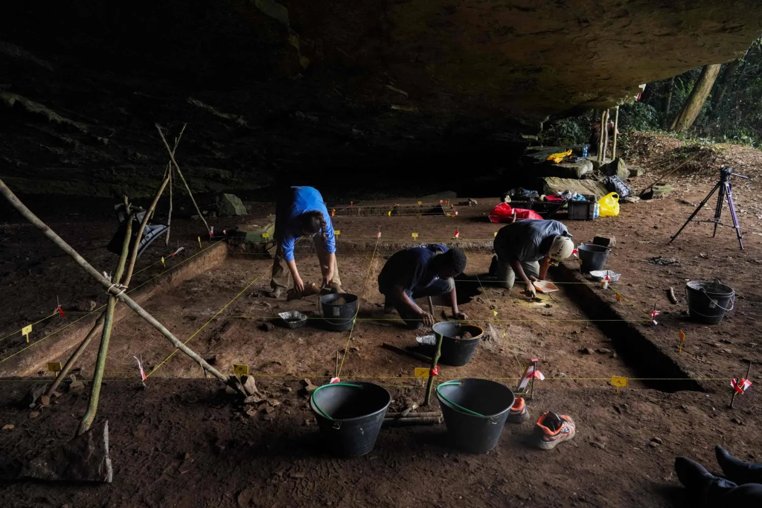
Off the beaten track even for archaeologists, the Youmbidi rock shelter, a cavern typical of those chosen by prehistoric humans to set up their homes, is the focus for French geoarchaeologist Richard Oslisly's team, AFP reported.

Among their finds: a stone tool which could have been used for cutting or making fibers dating to before 10,000 BC.

An arrowhead has also been unearthed, as has a collection of dolomite, quartz and jasper shards, cut up to 10,000 years ago by the cave's inhabitants.

"The vast majority of research in Africa has taken place in open landscapes such as the Sahara, Sahel or Egypt," said Oslisly, who has spent 45 years working in central Africa.

"They said to me 'there's nothing in the forest' (but) I took up the challenge of finding out what was happening there," he added.

"We realize there is a very close relationship between man and nature in these forests, where people have lived for a very long time," Oslisly said.

The Youmbidi cave -- where scientists have recorded 12,000 years of continuous human habitation -- is an enticing spot for the archeologists.

"We don't know at all how these people lived, what their way of life was, what their names were, what their languages were," said Geoffroy de Saulieu from France's IRD Research Institute for Development.

"Our research will help us to know a little more," he added.

After a month of digging and careful sorting of every stone, charcoal remnant, bone and other treasure buried below the cave, the team has elements to help decipher the past.
De Saulieu said it was like a jigsaw puzzle.

"You have to... gather the smallest clues, place them end to end to gradually reconstruct a whole universe that has disappeared and which is, nevertheless, at the origin of the way of life in central Africa today," said the expert, currently attached to the National Agency of National Parks of Gabon.

One of the oldest bits of pottery found in central Africa, which dated to more than 6,500 years ago, is among this year's finds.

Human-looking teeth that could allow DNA to be extracted in what would prove a significant leap in research have also excited archaeologists.

And, like all the artifacts, a bead likely made between 3,300 and 4,900 years ago from a snail shell also offers precious insight as a "very humble but beautiful witness" of the epoch in question.

Dispelling stereotypical images of prehistoric Man, it suggests people had "real customs, a real civilization and art of living," de Saulieu said.

The pottery "shows that these societies weren't immobile, they had launched themselves into technical innovations", he added.

The discoveries fan his fascination for the richness of "the social life which existed in the region's forests".

Glimpses into an ancient lost world can also be useful for tackling present-day challenges, the experts said.

During the Holocene period which dates back the past 12,000 years, "central Africa has experienced very significant changes in climate, hydrology and vegetation," said paleoclimatologist Yannick Garcin, also from the IRD and involved in the Youmbidi dig.

The hope is that the cave will unlock an understanding of "the resilience of human populations in the past and how they were able to adapt to climate changes that could have been drastic", he said.

Central Africa for that reason "deserves major development in terms of research", Oslisly argued.

Understanding what happened in prehistoric times can help scientists today react to modern-day issues, he added.

"Good studies on the relationship between Man and the environment in the past will allow us to react better to the environmental changes that are ahead of us," he said.


Saudi Arabia Reaffirms Commitment to Environmental Action on Saudi Green Initiative Day

One of the mountainous areas located in the south of the Kingdom of Saudi Arabia (Asharq Al-Awsat)
TT

Saudi Arabia Reaffirms Commitment to Environmental Action on Saudi Green Initiative Day

One of the mountainous areas located in the south of the Kingdom of Saudi Arabia (Asharq Al-Awsat)

The Saudi Green Initiative (SGI) Day, observed annually on March 27 following a Cabinet decision, reflects the Kingdom's commitment to establishing a culture of sustainability, enhancing national environmental efforts, and encouraging all sectors to achieve sustainable development goals in line with Vision 2030, SPA reported.

The initiative recently achieved a significant national milestone by rehabilitating one million hectares of degraded land through the National Greening Program, overseen by the National Center for Vegetation Cover Development and Combating Desertification. This objective aims to expand vegetation cover, reduce desertification, improve quality of life, and enhance the natural capacity of local environments to adapt to climate change.

The achievement is an extension of the Kingdom's broader efforts to protect natural resources, reduce emissions, promote reliance on clean energy, and preserve biodiversity, thereby strengthening Saudi Arabia's regional and international standing in environmental action.

Over the past year, the initiative has continued to make tangible progress. More than 159 million trees were planted across the Kingdom, and environmental reserves saw the birth of Arabian oryx calves for the third consecutive year. Furthermore, the National Water Efficiency and Conservation Center currently saves 120,000 cubic meters of water daily, with plans to increase this capacity to 300,000 cubic meters.

These combined efforts align with the objectives of Vision 2030 and contribute to strengthening the Kingdom’s regional and international standing in environmental sustainability.

SGI Day is observed annually to highlight the initiative’s achievements, review its future goals, and encourage broad sector participation in environmental efforts and sustainable development.

These efforts reflect the Kingdom’s approach to environmental and climate action, driven by the Saudi Green Initiative and the Middle East Green Initiative, both launched by Prince Mohammed bin Salman bin Abdulaziz Al Saud, Crown Prince and Prime Minister, underscoring its ongoing commitment to supporting the transition toward a more sustainable development model.


Satellite Observations Offer Insight into a Tsunami’s Early Stages

A person shows a cell phone displaying a message to evacuate to a tsunami safety zone during an evacuation of the coast following a tsunami warning issued by local authorities after an earthquake struck the Kamchatka Peninsula in the far east of Russia, triggering warnings and evacuations across the South Pacific, in Dichato, near Concepcion, Chile, July 30, 2025. (Reuters)
TT

Satellite Observations Offer Insight into a Tsunami’s Early Stages

A person shows a cell phone displaying a message to evacuate to a tsunami safety zone during an evacuation of the coast following a tsunami warning issued by local authorities after an earthquake struck the Kamchatka Peninsula in the far east of Russia, triggering warnings and evacuations across the South Pacific, in Dichato, near Concepcion, Chile, July 30, 2025. (Reuters)

Observations made by a satellite operated by the US and French space agencies shortly after a strong earthquake struck off Russia's Kamchatka Peninsula last year are giving scientists a better understanding of how tsunamis originate and propagate.

The researchers said the findings may help improve understanding of future tsunamis and earthquakes at subduction zones, particularly near the ocean trench where two tectonic plates meet and one slides beneath the other. The strongest tsunamis often are generated by such quakes.

The magnitude 8.8 quake struck on July 29, 2025, triggering a tsunami that spread across the Pacific Ocean. A tsunami - a series of extremely long and powerful ocean waves - is caused by large movements of the seafloor that push water up or down, often during earthquakes or landslides that occur under water.

The NASA-CNES Surface Water and Ocean Topography, or SWOT, satellite ‌made its observations ‌within 70 minutes of the start of the earthquake. It observed not ‌only ⁠the leading wave ⁠of the tsunami, but also a distinct pattern of smaller waves trailing behind it.

Such wave patterns had long been predicted in computer models and theoretical studies, but had been difficult to confirm with real-world observations, the researchers said.

"I believe SWOT represents a new lens for observing and studying tsunamis and their generation," said Ignacio Sepúlveda, a professor of coastal engineering at San Diego State University and lead author of the study published this week in the journal Science.

"It is also likely to improve our understanding of the physical mechanisms that generate tsunamis, including earthquakes," ⁠Sepúlveda added.

Traditional deep-ocean pressure sensors and other satellites have limitations in coverage ‌and measurement, making it difficult to capture the full structure of ‌the waves, especially near the trench, the researchers said.

SWOT scans a wide swath of the ocean, producing two-dimensional maps ‌of sea surface height. This allows scientists to see the shape, direction and spacing of tsunami waves ‌in much greater detail.

Tsunamis are among the strongest and most destructive natural forces, with powerful waves radiating from a point of origin outward in all directions. These waves can cause damaging and deadly coastal flooding.

The tsunami in this study did not cause significant loss of life, but others have caused huge death tolls such as the 2004 Indian Ocean ‌tsunami that killed some 230,000 people.

The July 2025 tsunami originated within about 10 kilometers (six miles) of the trench, the place in the seafloor ⁠where two tectonic plates intersect, ⁠the researchers found. This location could not previously be determined using traditional land-based instruments or sparse sensors on the seafloor alone.

Earth's surface is made up of immense plates that move very gradually in a geological process called plate tectonics.

The researchers found that when earthquake-caused movement extends close to the trench, it can generate shorter waves that travel more slowly and spread out over time, forming a trailing pattern behind the main tsunami front. This behavior means that different parts of the wave move at different speeds, with longer waves moving more quickly and leading, while shorter ones lag behind.

The study also showed that the strength of the trailing waves increases when earthquake movement extends closer to the trench, suggesting these waves are linked to where and how the tsunami was generated near the trench.

"This opens a new window to understand in a better way what happens with earthquakes and tsunamis near the trench," Sepúlveda said, referring to SWOT observations. "In the future, this knowledge will allow us to improve models we use to evaluate tsunami hazards in coastal communities and make them more resilient."


Gabon Battles for Baby Sea Turtles’ Survival

 An olive ridley sea turtle hatchling moves on a beach after emerging from its nest near Libreville on February 15, 2026. (AFP)
An olive ridley sea turtle hatchling moves on a beach after emerging from its nest near Libreville on February 15, 2026. (AFP)
TT

Gabon Battles for Baby Sea Turtles’ Survival

 An olive ridley sea turtle hatchling moves on a beach after emerging from its nest near Libreville on February 15, 2026. (AFP)
An olive ridley sea turtle hatchling moves on a beach after emerging from its nest near Libreville on February 15, 2026. (AFP)

Small enough to fit in the palm of your hand, newly hatched sea turtles emerged on a Gabonese beach to embark on the treacherous 10-meter (33-foot) scramble across the sand to the ocean.

"The survival rate for turtles is one in 1,000," Francois Boussamba, a Gabonese turtle expert and head of the NGO Aventures Sans Frontieres (Adventures Without Borders), told AFP, scouring for nests.

Conservationists from NGOs and the national parks agency patrol Gabon's beaches daily during the nesting season to protect the turtles' nests.

Those under threat are moved to a hatchery, a fenced enclosure near the sea, where the eggs are kept safe until they are ready to hatch.

On Pongara National Park's white sandy beaches, about 30 minutes by boat from the capital Libreville, conditions are optimal for nesting: wild coastline, a favorable equatorial climate and an open ocean beach with gentle slopes, ideal for the females.

But dangers lurk. Nests are threatened by coastal erosion due to encroaching sea levels, or myriad predators such as crabs and birds that prevent the eggs from reaching their 60-day incubation period, Boussamba said.

"The chances of survival are tiny," he said.

- Muscle up -

In Libreville, every morning around 7:00 am, volunteers from the Project Turtles Tahiti Gabon association crisscross the beach and check the nests in the hatchery.

After one has hatched, the baby turtles have to be moved so they can reach the sea -- but they are never put straight into the water.

"They need to build up their muscles so they can swim in the ocean," volunteer Clemence said.

Four species of turtles -- green, olive ridley, hawksbill and leatherback -- come to nest along Gabon's 900 kilometers (560 miles) of coastline from October to April.

It has the highest nesting density on the African continent, according to the US-based NGO Wildlife Conservation Society.

Gabon is the world's leading nesting site for the leatherback turtle, the largest of the species and listed as threatened by the International Union for Conservation of Nature (IUCN).

In addition to predators, sea turtles are also threatened by human activities, from plastic pollution to industrial fishing and poachers.

By watching over the eggs, the rangers in Pongara help ensure "the survival of this species", Edouard Moussavou, Pongara park's deputy director, said.

- Unpaid wages -

Since 2013, Gabon's conservation efforts had received funding from the United States, notably through the US Fish and Wildlife Service, an agency responsible for biodiversity.

"If there are turtles, it means our ecosystem is sound and healthy," Boussamba said.

But since the suspension of grants by the administration of US President Donald Trump, "turtle monitoring activities have stopped or slowed down drastically", Moussavou said.

"There will be fewer staff, less data, and that really creates difficulties for us," he said.

Additionally, there have been delays in paying the staff of the National Agency for National Parks (ANPN), which manages the country's 13 parks, according to Sosthene Ndong Engonga, secretary-general of the National Union of Gabonese Ecoguards.

The around 580 eco-rangers regularly go unpaid.

"Even when there is money, we have to make a big fuss to get our salaries," he said, adding he battled with the treasury last month for back pay.

The eco-rangers, who are crucial for the conservation of Gabon's biodiversity, face having "to give everything up," Engonga warned. "We have expenses we can no longer cover," he said.

On Pongara beach, 40-year-old Alain Banguiya carries out night patrols, hoping to see a leatherback turtle emerge from the water to lay her eggs in the sand.

An eco-ranger since 2015, he has not been paid for two months but says that giving up is out of the question.

"We have a duty to fight to the end, to keep our spirits up," he said. "Despite the obstacles, we stay the course: conservation."